

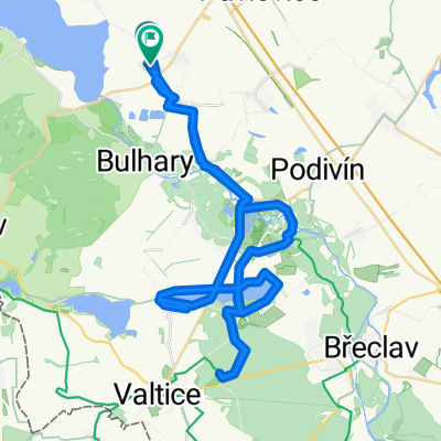
Přítluky - mandlový sad 2017
A cycling route starting in Zaječí, South Moravian, Czechia.
Overview
About this route
- -:--
- Duration
- 41.9 km
- Distance
- 483 m
- Ascent
- 483 m
- Descent
- ---
- Avg. speed
- ---
- Max. altitude

Route quality
Waytypes & surfaces along the route
Waytypes
Track
14.2 km
(34 %)
Road
13 km
(31 %)
Surfaces
Paved
13.4 km
(32 %)
Unpaved
10.9 km
(26 %)
Asphalt
10.9 km
(26 %)
Gravel
5.9 km
(14 %)
Route highlights
Points of interest along the route
Point of interest after 1.9 km
Byla tu keš
Point of interest after 3.1 km
keš Rozcesti mezi vinohrady [III.]
Point of interest after 3.3 km
odbočka keš
Point of interest after 4.1 km
keš Kaplicka sv. Floriána [I.]
Point of interest after 7.6 km
odbočka keš
Point of interest after 7.6 km
keš Vyhledy na Palavu
Point of interest after 10.1 km
Keš Tudy utikali
Point of interest after 11.6 km
Keš Mezi vinohrady
Point of interest after 13.2 km
Keš Zeleznicni nehody - Sakvice
Point of interest after 17.2 km
odbočka keš
Point of interest after 17.3 km
Keš Kaple sv. Rocha
Point of interest after 19.1 km
odbočka pro keš
Point of interest after 19.1 km
Keš Hustopecske koupaliste
Point of interest after 20.5 km
Keš Mandlonova rozhledna
Point of interest after 21.7 km
Odbočka pro keš
Point of interest after 21.9 km
Keš Tamhle je Palava v.2
Point of interest after 22.2 km
Keš Kamenny vrch u Kurdejova
Point of interest after 24.6 km
odbočka keš
Point of interest after 24.7 km
Keš Kurdejovsky krizek
Point of interest after 31.8 km
odbočka keš
Point of interest after 31.9 km
keš Velkopavlovicky Sv.Urban
Continue with Bikemap
Use, edit, or download this cycling route
You would like to ride Přítluky - mandlový sad 2017 or customize it for your own trip? Here is what you can do with this Bikemap route:
Free features
- Save this route as favorite or in collections
- Copy & plan your own version of this route
- Sync your route with Garmin or Wahoo
Premium features
Free trial for 3 days, or one-time payment. More about Bikemap Premium.
- Navigate this route on iOS & Android
- Export a GPX / KML file of this route
- Create your custom printout (try it for free)
- Download this route for offline navigation
Discover more Premium features.
Get Bikemap PremiumFrom our community
Other popular routes starting in Zaječí
 Vinařská do Zámecké náměstí
- Distance
- 36.4 km
- Ascent
- 162 m
- Descent
- 264 m
- Location
- Zaječí, South Moravian, Czechia
 Zaječí do Vinařská
- Distance
- 81.9 km
- Ascent
- 498 m
- Descent
- 541 m
- Location
- Zaječí, South Moravian, Czechia
 Putování po Modrých horách
- Distance
- 48.7 km
- Ascent
- 510 m
- Descent
- 510 m
- Location
- Zaječí, South Moravian, Czechia
 Vinařská do Vinařská
- Distance
- 58.9 km
- Ascent
- 590 m
- Descent
- 635 m
- Location
- Zaječí, South Moravian, Czechia
 Přítluky do Silnice Bez Názvu
- Distance
- 22.3 km
- Ascent
- 91 m
- Descent
- 87 m
- Location
- Zaječí, South Moravian, Czechia
 Přítluky - mandlový sad 2017
- Distance
- 41.9 km
- Ascent
- 483 m
- Descent
- 483 m
- Location
- Zaječí, South Moravian, Czechia
 Lednice Valtice Dyje 55 km
- Distance
- 55.2 km
- Ascent
- 156 m
- Descent
- 155 m
- Location
- Zaječí, South Moravian, Czechia
 Vinařská do Vinařská
- Distance
- 59.6 km
- Ascent
- 497 m
- Descent
- 548 m
- Location
- Zaječí, South Moravian, Czechia
Open it in the app