

ARMA-ARMA
A cycling route starting in Taggia, Liguria, Italy.
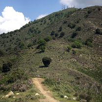
Overview
About this route
Arma-Ventimiglia-Dolceacqua-Passo Gouta-Castel Vittorio-Carmo Langan-Monte Ceppo-Vignai-Arma
- -:--
- Duration
- 123.6 km
- Distance
- 2,642 m
- Ascent
- 2,655 m
- Descent
- ---
- Avg. speed
- ---
- Max. altitude

Route quality
Waytypes & surfaces along the route
Waytypes
Busy road
57.5 km
(47 %)
Road
36.8 km
(30 %)
Surfaces
Paved
74.2 km
(60 %)
Unpaved
6 km
(5 %)
Asphalt
73.4 km
(59 %)
Ground
3.2 km
(3 %)
Continue with Bikemap
Use, edit, or download this cycling route
You would like to ride ARMA-ARMA or customize it for your own trip? Here is what you can do with this Bikemap route:
Free features
- Save this route as favorite or in collections
- Copy & plan your own version of this route
- Split it into stages to create a multi-day tour
- Sync your route with Garmin or Wahoo
Premium features
Free trial for 3 days, or one-time payment. More about Bikemap Premium.
- Navigate this route on iOS & Android
- Export a GPX / KML file of this route
- Create your custom printout (try it for free)
- Download this route for offline navigation
Discover more Premium features.
Get Bikemap PremiumFrom our community
Other popular routes starting in Taggia
 ARMA-ARMA
- Distance
- 123.6 km
- Ascent
- 2,642 m
- Descent
- 2,655 m
- Location
- Taggia, Liguria, Italy
 Colle Melosa
- Distance
- 101.6 km
- Ascent
- 2,794 m
- Descent
- 2,792 m
- Location
- Taggia, Liguria, Italy
 Giro a velocità lenta in Taggia
- Distance
- 38.5 km
- Ascent
- 1,364 m
- Descent
- 1,368 m
- Location
- Taggia, Liguria, Italy
 ARMA-ARMA
- Distance
- 137.9 km
- Ascent
- 3,341 m
- Descent
- 3,341 m
- Location
- Taggia, Liguria, Italy
 Giro di Perinaldo
- Distance
- 70.7 km
- Ascent
- 1,693 m
- Descent
- 1,696 m
- Location
- Taggia, Liguria, Italy
 Giro di Isolabona
- Distance
- 74.9 km
- Ascent
- 978 m
- Descent
- 990 m
- Location
- Taggia, Liguria, Italy
 Small Climbs Close to the Coast
- Distance
- 87.8 km
- Ascent
- 1,371 m
- Descent
- 1,364 m
- Location
- Taggia, Liguria, Italy
 Arma di Taggia - Poggio - Ceriana - Baiardo - Monte Ceppo
- Distance
- 34.8 km
- Ascent
- 1,633 m
- Descent
- 130 m
- Location
- Taggia, Liguria, Italy
Open it in the app