

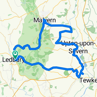
Ledbury VultureFish
A cycling route starting in Ledbury, England, United Kingdom.
Overview
About this route
Ledbury
Eastnor
HolyBush
Longdon
Bushley
(Weir)
Forthampton
Corse Lawn
Eldersfield
Chase End Street
Holybush
Ledbury
- -:--
- Duration
- 52.9 km
- Distance
- 467 m
- Ascent
- 432 m
- Descent
- ---
- Avg. speed
- 168 m
- Max. altitude

Route quality
Waytypes & surfaces along the route
Waytypes
Quiet road
27.8 km
(53 %)
Busy road
20.7 km
(39 %)
Surfaces
Paved
3 km
(6 %)
Asphalt
3 km
(6 %)
Undefined
49.8 km
(94 %)
Continue with Bikemap
Use, edit, or download this cycling route
You would like to ride Ledbury VultureFish or customize it for your own trip? Here is what you can do with this Bikemap route:
Free features
- Save this route as favorite or in collections
- Copy & plan your own version of this route
- Sync your route with Garmin or Wahoo
Premium features
Free trial for 3 days, or one-time payment. More about Bikemap Premium.
- Navigate this route on iOS & Android
- Export a GPX / KML file of this route
- Create your custom printout (try it for free)
- Download this route for offline navigation
Discover more Premium features.
Get Bikemap PremiumFrom our community
Other popular routes starting in Ledbury
 Liesure Ride 2010-03-13
- Distance
- 34.4 km
- Ascent
- 228 m
- Descent
- 236 m
- Location
- Ledbury, England, United Kingdom
 Ledbury Bosbury Balloon
- Distance
- 18.2 km
- Ascent
- 143 m
- Descent
- 143 m
- Location
- Ledbury, England, United Kingdom
 The Dog from Ledbury
- Distance
- 64.7 km
- Ascent
- 520 m
- Descent
- 520 m
- Location
- Ledbury, England, United Kingdom
 Medium route with a couple of nice hills!!
- Distance
- 46.9 km
- Ascent
- 488 m
- Descent
- 498 m
- Location
- Ledbury, England, United Kingdom
 Ledbury Flint
- Distance
- 25 km
- Ascent
- 372 m
- Descent
- 373 m
- Location
- Ledbury, England, United Kingdom
 LedburyCC.org - Dymock 9
- Distance
- 14.4 km
- Ascent
- 65 m
- Descent
- 63 m
- Location
- Ledbury, England, United Kingdom
 Ledbury Spiked Sausage Dog
- Distance
- 44.9 km
- Ascent
- 541 m
- Descent
- 541 m
- Location
- Ledbury, England, United Kingdom
 MTB Ride with Rob Davies + 8 + Rita (1st Ride)
- Distance
- 24.4 km
- Ascent
- 480 m
- Descent
- 477 m
- Location
- Ledbury, England, United Kingdom
Open it in the app