
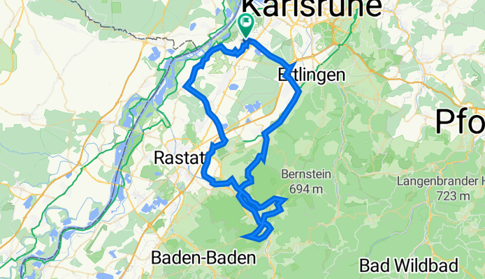
Badische Eröffnungsfahrt - RTF des RSV Concordia 1920 Forchheim e.V. - 76 km Strecke
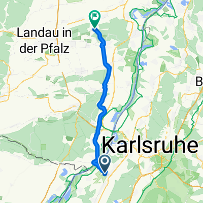
A cycling route starting in Rheinstetten, Baden-Wurttemberg, Germany.
Overview
About this route
Badische Eröffnungfahrt - 76 km
RTF of RSV Concordia 1920 Forchheim e.V.
All further information about this route -> click here
- -:--
- Duration
- 76.5 km
- Distance
- 325 m
- Ascent
- 325 m
- Descent
- ---
- Avg. speed
- ---
- Max. altitude

Route quality
Waytypes & surfaces along the route
Waytypes
Road
22.2 km
(29 %)
Quiet road
16.1 km
(21 %)
Surfaces
Paved
74.2 km
(97 %)
Asphalt
71.9 km
(94 %)
Paved (undefined)
2.3 km
(3 %)
Undefined
2.3 km
(3 %)
Continue with Bikemap
Use, edit, or download this cycling route
You would like to ride Badische Eröffnungsfahrt - RTF des RSV Concordia 1920 Forchheim e.V. - 76 km Strecke or customize it for your own trip? Here is what you can do with this Bikemap route:
Free features
- Save this route as favorite or in collections
- Copy & plan your own version of this route
- Sync your route with Garmin or Wahoo
Premium features
Free trial for 3 days, or one-time payment. More about Bikemap Premium.
- Navigate this route on iOS & Android
- Export a GPX / KML file of this route
- Create your custom printout (try it for free)
- Download this route for offline navigation
Discover more Premium features.
Get Bikemap PremiumFrom our community
Other popular routes starting in Rheinstetten
 KA-Flensburg
- Distance
- 1,114 km
- Ascent
- 595 m
- Descent
- 704 m
- Location
- Rheinstetten, Baden-Wurttemberg, Germany
 Radrunde Durmersheim - Rheinstetten
- Distance
- 19 km
- Ascent
- 19 m
- Descent
- 19 m
- Location
- Rheinstetten, Baden-Wurttemberg, Germany
 Badische Eröffnungsfahrt - RTF des RSV Concordia 1920 Forchheim e.V. - 76 km Strecke
- Distance
- 76.5 km
- Ascent
- 325 m
- Descent
- 325 m
- Location
- Rheinstetten, Baden-Wurttemberg, Germany
 RTF Concordia Forchheim (154 KM)
- Distance
- 153.2 km
- Ascent
- 3,630 m
- Descent
- 3,600 m
- Location
- Rheinstetten, Baden-Wurttemberg, Germany
 Frankreichrunde
- Distance
- 70.8 km
- Ascent
- 64 m
- Descent
- 66 m
- Location
- Rheinstetten, Baden-Wurttemberg, Germany
 RR -Verkehrsarme " Fünf Täler Rundtour" - Rheintal, Albtal, Eyachtal, Enztal & Murgtal.
- Distance
- 104.7 km
- Ascent
- 1,027 m
- Descent
- 1,029 m
- Location
- Rheinstetten, Baden-Wurttemberg, Germany
 Karlsruhe -Leimersheim Fähre-Insel Rott-Hochstetten und zurück CLONED FROM ROUTE 6259
- Distance
- 53.2 km
- Ascent
- 55 m
- Descent
- 58 m
- Location
- Rheinstetten, Baden-Wurttemberg, Germany
 nach zeiskam
- Distance
- 37.3 km
- Ascent
- 146 m
- Descent
- 134 m
- Location
- Rheinstetten, Baden-Wurttemberg, Germany
Open it in the app