

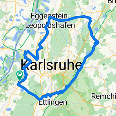
RTF durch's Badnerland des RSV Concordia 1920 Forchheim e.V. - 52 km Strecke
A cycling route starting in Rheinstetten, Baden-Wurttemberg, Germany.
Overview
About this route
RTF durch's Badnerland - 54 km
RTF des RSV Concordia 1920 Forchheim e.V.
Alle weiteren Hinweise zu dieser Strecke -> hier anklicken
- -:--
- Duration
- 52.9 km
- Distance
- 128 m
- Ascent
- 128 m
- Descent
- ---
- Avg. speed
- ---
- Max. altitude

Route quality
Waytypes & surfaces along the route
Waytypes
Busy road
18.3 km
(35 %)
Road
13.7 km
(26 %)
Surfaces
Paved
52 km
(98 %)
Unpaved
0.3 km
(<1 %)
Asphalt
50.7 km
(96 %)
Paved (undefined)
1.3 km
(2 %)
Continue with Bikemap
Use, edit, or download this cycling route
You would like to ride RTF durch's Badnerland des RSV Concordia 1920 Forchheim e.V. - 52 km Strecke or customize it for your own trip? Here is what you can do with this Bikemap route:
Free features
- Save this route as favorite or in collections
- Copy & plan your own version of this route
- Sync your route with Garmin or Wahoo
Premium features
Free trial for 3 days, or one-time payment. More about Bikemap Premium.
- Navigate this route on iOS & Android
- Export a GPX / KML file of this route
- Create your custom printout (try it for free)
- Download this route for offline navigation
Discover more Premium features.
Get Bikemap PremiumFrom our community
Other popular routes starting in Rheinstetten
 Radwallfahrt zur St. Annakapelle in Burrweiler mit Einkehrschwung im höchst gelegenen Weingut der Pfalz.
- Distance
- 110.6 km
- Ascent
- 464 m
- Descent
- 464 m
- Location
- Rheinstetten, Baden-Wurttemberg, Germany
 Karlsruhe Heidelberg
- Distance
- 87.4 km
- Ascent
- 81 m
- Descent
- 85 m
- Location
- Rheinstetten, Baden-Wurttemberg, Germany
 aus Rheinstetten in den Kraichgau mit Ortsdurchfahrten von Forchheim - KA Daxlanden - KA Knielingen - Eggenstein - Leopoldshafen - Staffort - Untergrombach - Ob
- Distance
- 112.2 km
- Ascent
- 420 m
- Descent
- 418 m
- Location
- Rheinstetten, Baden-Wurttemberg, Germany
 Rund um die badische Residenz.
- Distance
- 64.9 km
- Ascent
- 161 m
- Descent
- 166 m
- Location
- Rheinstetten, Baden-Wurttemberg, Germany
 Von Rheinstetten zum Campus Nord des KIT
- Distance
- 20.6 km
- Ascent
- 35 m
- Descent
- 37 m
- Location
- Rheinstetten, Baden-Wurttemberg, Germany
![[DAY 30] Karlsruhe - Mannheim](https://media.bikemap.net/routes/8670248/gallery/thumbs/15f9a61d-1656-4590-9f52-52fc5fa4a7d0.jpeg.208x208_q80_crop.jpg) [DAY 30] Karlsruhe - Mannheim
[DAY 30] Karlsruhe - Mannheim- Distance
- 85.4 km
- Ascent
- 58 m
- Descent
- 72 m
- Location
- Rheinstetten, Baden-Wurttemberg, Germany
 durch das ruhige Nordelsaß - eine Tour durch bodenständige Dörfer mit schönen Fachwerkhäusern.
- Distance
- 96.9 km
- Ascent
- 228 m
- Descent
- 221 m
- Location
- Rheinstetten, Baden-Wurttemberg, Germany
 durch das Murgtal nach Bermersbach, die Rote Lache über den Scherrhof nach Baden-Baden, Balg, Haueneberstein, Kuppenheim und Muggensturm nach Malsch und zurück
- Distance
- 98.7 km
- Ascent
- 678 m
- Descent
- 686 m
- Location
- Rheinstetten, Baden-Wurttemberg, Germany
Open it in the app