

ride through Rome
A cycling route starting in Valcanneto, Lazio, Italy.
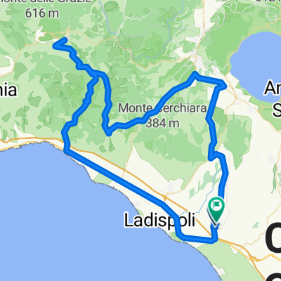
Overview
About this route
mixed surface concrete and offroad
- 52 min
- Duration
- 16.5 km
- Distance
- 68 m
- Ascent
- 39 m
- Descent
- 18.9 km/h
- Avg. speed
- ---
- Max. altitude

Continue with Bikemap
Use, edit, or download this cycling route
You would like to ride ride through Rome or customize it for your own trip? Here is what you can do with this Bikemap route:
Free features
- Save this route as favorite or in collections
- Copy & plan your own version of this route
- Sync your route with Garmin or Wahoo
Premium features
Free trial for 3 days, or one-time payment. More about Bikemap Premium.
- Navigate this route on iOS & Android
- Export a GPX / KML file of this route
- Create your custom printout (try it for free)
- Download this route for offline navigation
Discover more Premium features.
Get Bikemap PremiumFrom our community
Other popular routes starting in Valcanneto
 ride through Rome
- Distance
- 16.5 km
- Ascent
- 68 m
- Descent
- 39 m
- Location
- Valcanneto, Lazio, Italy
 Torrimpietra Civitavecchia
- Distance
- 82.9 km
- Ascent
- 125 m
- Descent
- 133 m
- Location
- Valcanneto, Lazio, Italy
 civitavecchia
- Distance
- 87.2 km
- Ascent
- 165 m
- Descent
- 166 m
- Location
- Valcanneto, Lazio, Italy
 Valc_Monterosi_Martignano_Valcann.
- Distance
- 92.5 km
- Ascent
- 857 m
- Descent
- 848 m
- Location
- Valcanneto, Lazio, Italy
 Borgo Ceri
- Distance
- 20.3 km
- Ascent
- 167 m
- Descent
- 266 m
- Location
- Valcanneto, Lazio, Italy
 Palidoro - Tolfa - Sasso - Palidoro
- Distance
- 106.2 km
- Ascent
- 852 m
- Descent
- 852 m
- Location
- Valcanneto, Lazio, Italy
 Valc_Tolfa_Bracciano_Valc
- Distance
- 102.8 km
- Ascent
- 989 m
- Descent
- 986 m
- Location
- Valcanneto, Lazio, Italy
 Da Valcanneto a remissini di Tolfa e ritorno
- Distance
- 73.4 km
- Ascent
- 661 m
- Descent
- 667 m
- Location
- Valcanneto, Lazio, Italy
Open it in the app