

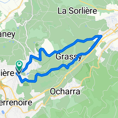
st jean bonnefonds - saint andré le puy
A cycling route starting in Saint-Jean-Bonnefonds, Auvergne-Rhône-Alpes, France.
Overview
About this route
- -:--
- Duration
- 35.5 km
- Distance
- 144 m
- Ascent
- 328 m
- Descent
- ---
- Avg. speed
- ---
- Max. altitude

Route quality
Waytypes & surfaces along the route
Waytypes
Quiet road
15.6 km
(44 %)
Road
2.1 km
(6 %)
Surfaces
Paved
7.8 km
(22 %)
Asphalt
7.8 km
(22 %)
Undefined
27.7 km
(78 %)
Continue with Bikemap
Use, edit, or download this cycling route
You would like to ride st jean bonnefonds - saint andré le puy or customize it for your own trip? Here is what you can do with this Bikemap route:
Free features
- Save this route as favorite or in collections
- Copy & plan your own version of this route
- Sync your route with Garmin or Wahoo
Premium features
Free trial for 3 days, or one-time payment. More about Bikemap Premium.
- Navigate this route on iOS & Android
- Export a GPX / KML file of this route
- Create your custom printout (try it for free)
- Download this route for offline navigation
Discover more Premium features.
Get Bikemap PremiumFrom our community
Other popular routes starting in Saint-Jean-Bonnefonds
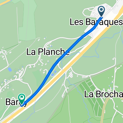 Route des Barraques, Saint-Chamond to Route des Barraques, Saint-Jean-Bonnefonds
- Distance
- 1.5 km
- Ascent
- 38 m
- Descent
- 17 m
- Location
- Saint-Jean-Bonnefonds, Auvergne-Rhône-Alpes, France
 De 7 Rue du Puits Lachaud, Saint-Étienne à 5 Allée du Galibot, Saint-Étienne
- Distance
- 9.1 km
- Ascent
- 226 m
- Descent
- 224 m
- Location
- Saint-Jean-Bonnefonds, Auvergne-Rhône-Alpes, France
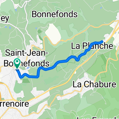 De Route de Terrenoire à Rue Victor Hugo
- Distance
- 8.4 km
- Ascent
- 152 m
- Descent
- 201 m
- Location
- Saint-Jean-Bonnefonds, Auvergne-Rhône-Alpes, France
 Route saint jean bonnefonds
- Distance
- 20.6 km
- Ascent
- 406 m
- Descent
- 462 m
- Location
- Saint-Jean-Bonnefonds, Auvergne-Rhône-Alpes, France
 De Rue de la Talaudière 63, Saint-Étienne à Rue Raoul Follereau 6, La Talaudière
- Distance
- 14.7 km
- Ascent
- 91 m
- Descent
- 81 m
- Location
- Saint-Jean-Bonnefonds, Auvergne-Rhône-Alpes, France
 st jean bonnefonds - saint andré le puy
- Distance
- 35.5 km
- Ascent
- 144 m
- Descent
- 328 m
- Location
- Saint-Jean-Bonnefonds, Auvergne-Rhône-Alpes, France
 test10
- Distance
- 177.1 km
- Ascent
- 2,665 m
- Descent
- 1,779 m
- Location
- Saint-Jean-Bonnefonds, Auvergne-Rhône-Alpes, France
 De Route de Terrenoire à Route de Terrenoire
- Distance
- 20.8 km
- Ascent
- 394 m
- Descent
- 441 m
- Location
- Saint-Jean-Bonnefonds, Auvergne-Rhône-Alpes, France
Open it in the app