

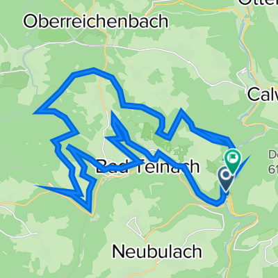
Bad Teinach
A cycling route starting in Bad Teinach-Zavelstein, Baden-Wurttemberg, Germany.
Overview
About this route
- -:--
- Duration
- 6.9 km
- Distance
- 218 m
- Ascent
- 216 m
- Descent
- ---
- Avg. speed
- ---
- Max. altitude

Route quality
Waytypes & surfaces along the route
Waytypes
Track
5.3 km
(77 %)
Path
1.1 km
(16 %)
Surfaces
Paved
0.7 km
(10 %)
Unpaved
5.7 km
(83 %)
Gravel
5.4 km
(78 %)
Paving stones
0.4 km
(5 %)
Continue with Bikemap
Use, edit, or download this cycling route
You would like to ride Bad Teinach or customize it for your own trip? Here is what you can do with this Bikemap route:
Free features
- Save this route as favorite or in collections
- Copy & plan your own version of this route
- Sync your route with Garmin or Wahoo
Premium features
Free trial for 3 days, or one-time payment. More about Bikemap Premium.
- Navigate this route on iOS & Android
- Export a GPX / KML file of this route
- Create your custom printout (try it for free)
- Download this route for offline navigation
Discover more Premium features.
Get Bikemap PremiumFrom our community
Other popular routes starting in Bad Teinach-Zavelstein
 Nord Schwarzwald - Bonn
- Distance
- 394 km
- Ascent
- 605 m
- Descent
- 1,111 m
- Location
- Bad Teinach-Zavelstein, Baden-Wurttemberg, Germany
 Schluchtenweg-Tour
- Distance
- 33.8 km
- Ascent
- 637 m
- Descent
- 583 m
- Location
- Bad Teinach-Zavelstein, Baden-Wurttemberg, Germany
 Nagoldtal-Radtour
- Distance
- 33.9 km
- Ascent
- 246 m
- Descent
- 316 m
- Location
- Bad Teinach-Zavelstein, Baden-Wurttemberg, Germany
 Rundfahrt: Teinach - Atensteig - Nagoldtasperre...
- Distance
- 94.3 km
- Ascent
- 805 m
- Descent
- 805 m
- Location
- Bad Teinach-Zavelstein, Baden-Wurttemberg, Germany
 Krokusstraße 22, Bad Teinach-Zavelstein nach Graf-Eberhard-Straße 4, Bad Teinach-Zavelstein
- Distance
- 35.2 km
- Ascent
- 559 m
- Descent
- 537 m
- Location
- Bad Teinach-Zavelstein, Baden-Wurttemberg, Germany
 Otto-Neidhart-Allee 5, Bad Teinach-Zavelstein nach Otto-Neidhart-Allee 5, Bad Teinach-Zavelstein
- Distance
- 45.4 km
- Ascent
- 1,875 m
- Descent
- 1,875 m
- Location
- Bad Teinach-Zavelstein, Baden-Wurttemberg, Germany
 Schluchtenweg-Tour
- Distance
- 33.1 km
- Ascent
- 590 m
- Descent
- 590 m
- Location
- Bad Teinach-Zavelstein, Baden-Wurttemberg, Germany
 Erlebnisreiche Rundwanderung mit wunderschöner Aussicht und Kultur
- Distance
- 10.4 km
- Ascent
- 380 m
- Descent
- 380 m
- Location
- Bad Teinach-Zavelstein, Baden-Wurttemberg, Germany
Open it in the app