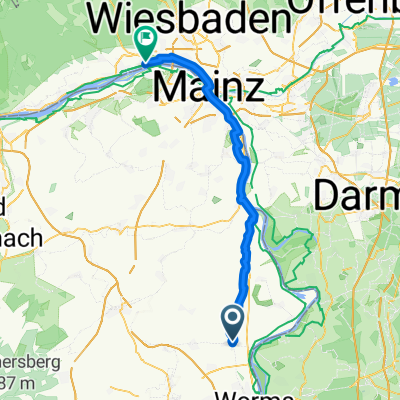
Eich Ludwigshöhe
A cycling route starting in Osthofen, Rhineland-Palatinate, Germany.
Overview
About this route
- 3 h 3 min
- Duration
- 41.9 km
- Distance
- 23 m
- Ascent
- 22 m
- Descent
- 13.7 km/h
- Avg. speed
- ---
- Avg. speed
Route quality
Waytypes & surfaces along the route
Waytypes
Track
20.1 km
(48 %)
Path
6.2 km
(15 %)
Surfaces
Paved
38 km
(90 %)
Unpaved
1.7 km
(4 %)
Asphalt
29.6 km
(71 %)
Paved (undefined)
5.6 km
(13 %)
Continue with Bikemap
Use, edit, or download this cycling route
You would like to ride Eich Ludwigshöhe or customize it for your own trip? Here is what you can do with this Bikemap route:
Free features
- Save this route as favorite or in collections
- Copy & plan your own version of this route
- Sync your route with Garmin or Wahoo
Premium features
Free trial for 3 days, or one-time payment. More about Bikemap Premium.
- Navigate this route on iOS & Android
- Export a GPX / KML file of this route
- Create your custom printout (try it for free)
- Download this route for offline navigation
Discover more Premium features.
Get Bikemap PremiumFrom our community
Other popular routes starting in Osthofen
- OH - Lindemannsruh
- Distance
- 86.4 km
- Ascent
- 560 m
- Descent
- 560 m
- Location
- Osthofen, Rhineland-Palatinate, Germany
- Wonnegaustraße 5, Osthofen to Backsteinweg 4A, Osthofen
- Distance
- 17.7 km
- Ascent
- 163 m
- Descent
- 163 m
- Location
- Osthofen, Rhineland-Palatinate, Germany
- Wonnegau-Rundfahrt - 46 km Permanente des RSV Rheindürkheim e.V.
- Distance
- 48.2 km
- Ascent
- 200 m
- Descent
- 200 m
- Location
- Osthofen, Rhineland-Palatinate, Germany
- Wonnegau-Rundfahrt - 74 km Permanente des RSV Rheindürkheim e.V.
- Distance
- 79.1 km
- Ascent
- 346 m
- Descent
- 348 m
- Location
- Osthofen, Rhineland-Palatinate, Germany
- Rundfahrt Rudi
- Distance
- 25.7 km
- Ascent
- 164 m
- Descent
- 161 m
- Location
- Osthofen, Rhineland-Palatinate, Germany
- MZ KFC
- Distance
- 77.2 km
- Ascent
- 384 m
- Descent
- 383 m
- Location
- Osthofen, Rhineland-Palatinate, Germany
- Rheindürkheimer Herbst-RTF des RSV Rheindürkheim e.V. - 113 km Strecke
- Distance
- 107.7 km
- Ascent
- 566 m
- Descent
- 566 m
- Location
- Osthofen, Rhineland-Palatinate, Germany
- Eich Ludwigshöhe
- Distance
- 41.9 km
- Ascent
- 23 m
- Descent
- 22 m
- Location
- Osthofen, Rhineland-Palatinate, Germany