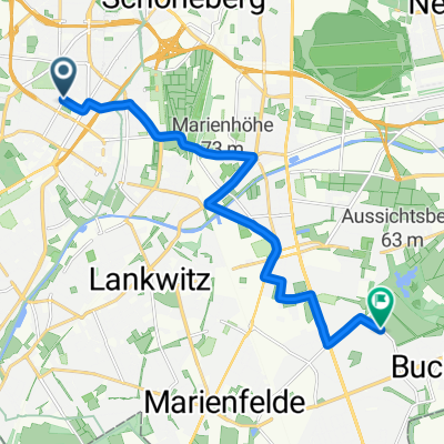
Friedenau - Wannsee - Potsdam - Sacrow - Spandau - zurück
A cycling route starting in Friedenau, State of Berlin, Germany.
Overview
About this route
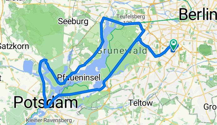
Lovely 70 km asphalt loop starting from Friedenau via:
S-Bahn station Grunewald - Wannsee - Glienicker Bridge - Dutch Quarter - Neu Fahrland - Sacrow - Kladow - Gatow - Spandau/Heestrasse - Jaffeestrasse - and back via Grunewald station.
While you are somewhat 'in traffic' on the outbound leg up to and on the return leg from S-BHF Grunewald, as well as in Potsdam, good bike paths run parallel to the road in parts. Often you can also use the roadway, as this route is heavily frequented by cyclists and motorists are, in my experience, mostly quite considerate.
- -:--
- Duration
- 69.6 km
- Distance
- 296 m
- Ascent
- 297 m
- Descent
- ---
- Avg. speed
- 88 m
- Max. altitude
Route quality
Waytypes & surfaces along the route
Waytypes
Quiet road
20.9 km
(30 %)
Path
14.6 km
(21 %)
Surfaces
Paved
58.5 km
(84 %)
Unpaved
1.4 km
(2 %)
Asphalt
57.1 km
(82 %)
Ground
1.4 km
(2 %)
Continue with Bikemap
Use, edit, or download this cycling route
You would like to ride Friedenau - Wannsee - Potsdam - Sacrow - Spandau - zurück or customize it for your own trip? Here is what you can do with this Bikemap route:
Free features
- Save this route as favorite or in collections
- Copy & plan your own version of this route
- Sync your route with Garmin or Wahoo
Premium features
Free trial for 3 days, or one-time payment. More about Bikemap Premium.
- Navigate this route on iOS & Android
- Export a GPX / KML file of this route
- Create your custom printout (try it for free)
- Download this route for offline navigation
Discover more Premium features.
Get Bikemap PremiumFrom our community
Other popular routes starting in Friedenau
- Dobbrikow kurz
- Distance
- 97.9 km
- Ascent
- 132 m
- Descent
- 131 m
- Location
- Friedenau, State of Berlin, Germany
- Rund um den Wannsee via Außenweg
- Distance
- 67.9 km
- Ascent
- 222 m
- Descent
- 219 m
- Location
- Friedenau, State of Berlin, Germany
- Hügelige Feierabendrunde
- Distance
- 68.3 km
- Ascent
- 505 m
- Descent
- 497 m
- Location
- Friedenau, State of Berlin, Germany
- S/U Bundesplatz - S Zehlendorf - Tremsdorf - Dobbrikow - Trebbin - Riesengroßbeuthen - Nudow - Drewitz - S Wannsee
- Distance
- 94.1 km
- Ascent
- 124 m
- Descent
- 124 m
- Location
- Friedenau, State of Berlin, Germany
- Feierabendrunde über Gröben & Ludwigsfelde
- Distance
- 68.7 km
- Ascent
- 95 m
- Descent
- 91 m
- Location
- Friedenau, State of Berlin, Germany
- Nachtfahrt Rennrad/Südwest
- Distance
- 26.9 km
- Ascent
- 70 m
- Descent
- 67 m
- Location
- Friedenau, State of Berlin, Germany
- He-GliB-Grieb-He
- Distance
- 49.8 km
- Ascent
- 287 m
- Descent
- 289 m
- Location
- Friedenau, State of Berlin, Germany
- Friedenau - Friedenau(Havelchausse; 36 KM)
- Distance
- 36.4 km
- Ascent
- 151 m
- Descent
- 150 m
- Location
- Friedenau, State of Berlin, Germany
Open it in the app