

Overview
About this route
From the sight of Ratcliffe-on-Soar to Willington along Mersey-Trent Canal and back via the "scenic route"
- -:--
- Duration
- 63.2 km
- Distance
- 141 m
- Ascent
- 144 m
- Descent
- ---
- Avg. speed
- ---
- Max. altitude

Part of
to-do
3 stages
Route quality
Waytypes & surfaces along the route
Waytypes
Pedestrian area
25.3 km
(40 %)
Quiet road
13.3 km
(21 %)
Surfaces
Paved
20.2 km
(32 %)
Unpaved
20.8 km
(33 %)
Asphalt
17.1 km
(27 %)
Gravel
10.1 km
(16 %)
Continue with Bikemap
Use, edit, or download this cycling route
You would like to ride All I See Is Powerstations... or customize it for your own trip? Here is what you can do with this Bikemap route:
Free features
- Save this route as favorite or in collections
- Copy & plan your own version of this route
- Sync your route with Garmin or Wahoo
Premium features
Free trial for 3 days, or one-time payment. More about Bikemap Premium.
- Navigate this route on iOS & Android
- Export a GPX / KML file of this route
- Create your custom printout (try it for free)
- Download this route for offline navigation
Discover more Premium features.
Get Bikemap PremiumFrom our community
Other popular routes starting in Long Eaton
 Leah test route - Moose Driving
- Distance
- 18.7 km
- Ascent
- 84 m
- Descent
- 86 m
- Location
- Long Eaton, England, United Kingdom
 Trent Lock to Diseworth via Shardlow
- Distance
- 17.1 km
- Ascent
- 95 m
- Descent
- 94 m
- Location
- Long Eaton, England, United Kingdom
 Brown Lane to Bradmore Avenue 8, Ruddington
- Distance
- 18.9 km
- Ascent
- 100 m
- Descent
- 90 m
- Location
- Long Eaton, England, United Kingdom
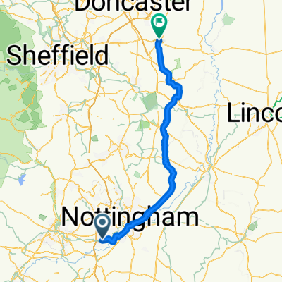 Day 15 Nottingham to Bawtry (Doncaster)
- Distance
- 90.1 km
- Ascent
- 404 m
- Descent
- 423 m
- Location
- Long Eaton, England, United Kingdom
 Beeston to Stanley Common
- Distance
- 50.6 km
- Ascent
- 338 m
- Descent
- 333 m
- Location
- Long Eaton, England, United Kingdom
 erewash trent circular
- Distance
- 45.7 km
- Ascent
- 0 m
- Descent
- 0 m
- Location
- Long Eaton, England, United Kingdom
 Embankment
- Distance
- 17.1 km
- Ascent
- 9 m
- Descent
- 9 m
- Location
- Long Eaton, England, United Kingdom
 College Street 295, Long Eaton to College Street 295, Long Eaton
- Distance
- 10.5 km
- Ascent
- 16 m
- Descent
- 53 m
- Location
- Long Eaton, England, United Kingdom
Open it in the app