

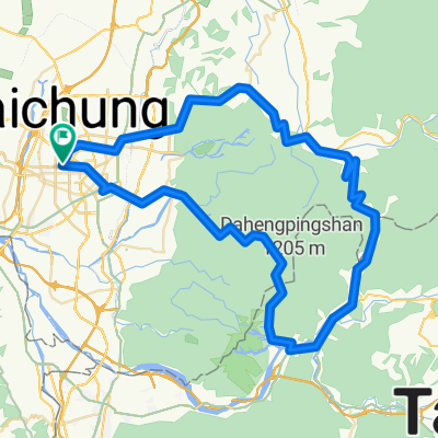
20170812獨行環島第二天-臺中~嘉義
A cycling route starting in Taichung, Taiwan, Taiwan.
Overview
About this route
均速20.0 距離131.93 時間6:34:58 最大速43.3
- -:--
- Duration
- 130.1 km
- Distance
- 63 m
- Ascent
- 82 m
- Descent
- ---
- Avg. speed
- ---
- Max. altitude

Route quality
Waytypes & surfaces along the route
Waytypes
Access road
32.5 km
(25 %)
Quiet road
19.5 km
(15 %)
Surfaces
Paved
11.7 km
(9 %)
Asphalt
11.7 km
(9 %)
Undefined
118.4 km
(91 %)
Continue with Bikemap
Use, edit, or download this cycling route
You would like to ride 20170812獨行環島第二天-臺中~嘉義 or customize it for your own trip? Here is what you can do with this Bikemap route:
Free features
- Save this route as favorite or in collections
- Copy & plan your own version of this route
- Split it into stages to create a multi-day tour
- Sync your route with Garmin or Wahoo
Premium features
Free trial for 3 days, or one-time payment. More about Bikemap Premium.
- Navigate this route on iOS & Android
- Export a GPX / KML file of this route
- Create your custom printout (try it for free)
- Download this route for offline navigation
Discover more Premium features.
Get Bikemap PremiumFrom our community
Other popular routes starting in Taichung
 東山路-大雪山
- Distance
- 47.1 km
- Ascent
- 1,841 m
- Descent
- 160 m
- Location
- Taichung, Taiwan, Taiwan
 台中北屯到后豐
- Distance
- 16.8 km
- Ascent
- 122 m
- Descent
- 10 m
- Location
- Taichung, Taiwan, Taiwan
 天冷+136
- Distance
- 99.7 km
- Ascent
- 1,364 m
- Descent
- 1,366 m
- Location
- Taichung, Taiwan, Taiwan
 龍寶橋_後壁涼亭
- Distance
- 3.7 km
- Ascent
- 334 m
- Descent
- 176 m
- Location
- Taichung, Taiwan, Taiwan
 德利路_十四窯坪_大石壁_牛角坑_德利路
- Distance
- 10.3 km
- Ascent
- 480 m
- Descent
- 483 m
- Location
- Taichung, Taiwan, Taiwan
 大神光_後壁
- Distance
- 10.3 km
- Ascent
- 386 m
- Descent
- 389 m
- Location
- Taichung, Taiwan, Taiwan
 安妮公主的中興嶺
- Distance
- 52.2 km
- Ascent
- 1,561 m
- Descent
- 1,161 m
- Location
- Taichung, Taiwan, Taiwan
 大坑步步高升 2000m
- Distance
- 89.4 km
- Ascent
- 1,789 m
- Descent
- 1,728 m
- Location
- Taichung, Taiwan, Taiwan
Open it in the app