

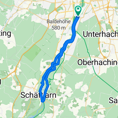
München-Andechs-München
A cycling route starting in Pullach im Isartal, Bavaria, Germany.
Overview
About this route
Munich-Planegg-KIM-Fronloh-Unterbrunn-Oberpfaffenhofen-Hochstadt-Unering-Drößling-Frieding-Andechs-Erling-Machtlfing-Landstetten-Perchting-Hadorf-Gauting-Buchendorf-Neuried-Munich
- -:--
- Duration
- 75.4 km
- Distance
- 247 m
- Ascent
- 244 m
- Descent
- ---
- Avg. speed
- ---
- Max. altitude

Route quality
Waytypes & surfaces along the route
Waytypes
Road
18.8 km
(25 %)
Path
15.1 km
(20 %)
Surfaces
Paved
67.1 km
(89 %)
Unpaved
3 km
(4 %)
Asphalt
66.3 km
(88 %)
Gravel
1.5 km
(2 %)
Continue with Bikemap
Use, edit, or download this cycling route
You would like to ride München-Andechs-München or customize it for your own trip? Here is what you can do with this Bikemap route:
Free features
- Save this route as favorite or in collections
- Copy & plan your own version of this route
- Sync your route with Garmin or Wahoo
Premium features
Free trial for 3 days, or one-time payment. More about Bikemap Premium.
- Navigate this route on iOS & Android
- Export a GPX / KML file of this route
- Create your custom printout (try it for free)
- Download this route for offline navigation
Discover more Premium features.
Get Bikemap PremiumFrom our community
Other popular routes starting in Pullach im Isartal
 Obersendling-Otterfing-Aying-Obersendling
- Distance
- 106.7 km
- Ascent
- 604 m
- Descent
- 577 m
- Location
- Pullach im Isartal, Bavaria, Germany
 Münchner Isartal-Tour
- Distance
- 33.3 km
- Ascent
- 237 m
- Descent
- 239 m
- Location
- Pullach im Isartal, Bavaria, Germany
 München-Andechs-Starnberg
- Distance
- 79.7 km
- Ascent
- 630 m
- Descent
- 598 m
- Location
- Pullach im Isartal, Bavaria, Germany
 München-Andechs-München
- Distance
- 75.4 km
- Ascent
- 247 m
- Descent
- 244 m
- Location
- Pullach im Isartal, Bavaria, Germany
 München - Gardasee Via Claudia Augusta
- Distance
- 478.1 km
- Ascent
- 3,545 m
- Descent
- 4,026 m
- Location
- Pullach im Isartal, Bavaria, Germany
 T2-Tierpark-Isartrails-Wolfratshausen-Runde
- Distance
- 60.6 km
- Ascent
- 241 m
- Descent
- 237 m
- Location
- Pullach im Isartal, Bavaria, Germany
 26.6. München - Ohlstadt
- Distance
- 73.5 km
- Ascent
- 653 m
- Descent
- 513 m
- Location
- Pullach im Isartal, Bavaria, Germany
 From Rosenheim to Kufstein
- Distance
- 80.8 km
- Ascent
- 351 m
- Descent
- 464 m
- Location
- Pullach im Isartal, Bavaria, Germany
Open it in the app