

COA COA DURA : GIRONE INFERNALE SARENTINO
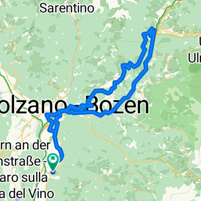
A cycling route starting in Bronzolo, Trentino-Alto Adige, Italy.
Overview
About this route
MASSACRANTE ma STUPENDO!!! DISLIVELLO TOTALE: 4300 metri (quasi quanto il CERVINO). COA DURA indispensabile. Da rivisitare le CASCATE sopra RACINES. PARTENZA ore 4:20 (Temp min: 10°); RITORNO ore 19:45. ATTENZIONE A:
-
Il DOWNHILL da Passo GIOVO lungo il sentiero 13 è OTTIMO nella 1^ parte fino alla seggiovia; poi diventa impraticabile per qualsiasi BICI.
-
Il DOWNHILL lungo la vallata sotto il Passo PENNES è assolutamente da evitare: sbarramenti di pietre ogni 20-50 mt. x scoraggiare le bici.
-
Il passo da SARENTINO - Malga MOLTNER KASER (sent. 23A) è DA VOMITO: miliardi di pietre rotolanti e radici che ti obbligano ad appiedare. Tuttavia dopo si aprono PRATI con LARICI IMPAGABILI. Meglio provare il passaggio x il sent. 5B e 5 che passa per JENESIER JOCHALM: magari è + fattibile.
VOTO FINALE: 9 e MEZZO!
- -:--
- Duration
- 190.1 km
- Distance
- 3,799 m
- Ascent
- 3,793 m
- Descent
- ---
- Avg. speed
- ---
- Max. altitude

Route quality
Waytypes & surfaces along the route
Waytypes
Busy road
78.2 km
(41 %)
Quiet road
29.9 km
(16 %)
Surfaces
Paved
119 km
(63 %)
Unpaved
19.5 km
(10 %)
Asphalt
116.7 km
(61 %)
Gravel
9.7 km
(5 %)
Continue with Bikemap
Use, edit, or download this cycling route
You would like to ride COA COA DURA : GIRONE INFERNALE SARENTINO or customize it for your own trip? Here is what you can do with this Bikemap route:
Free features
- Save this route as favorite or in collections
- Copy & plan your own version of this route
- Split it into stages to create a multi-day tour
- Sync your route with Garmin or Wahoo
Premium features
Free trial for 3 days, or one-time payment. More about Bikemap Premium.
- Navigate this route on iOS & Android
- Export a GPX / KML file of this route
- Create your custom printout (try it for free)
- Download this route for offline navigation
Discover more Premium features.
Get Bikemap PremiumFrom our community
Other popular routes starting in Bronzolo
 BRONZOLO-VERONA
- Distance
- 152 km
- Ascent
- 137 m
- Descent
- 320 m
- Location
- Bronzolo, Trentino-Alto Adige, Italy
 SAIT-LUPICINO-ENZBIRCH-VALLARSA
- Distance
- 43.4 km
- Ascent
- 1,461 m
- Descent
- 1,459 m
- Location
- Bronzolo, Trentino-Alto Adige, Italy
 Passo MENDOLA + SENT. 508.
- Distance
- 80 km
- Ascent
- 1,656 m
- Descent
- 1,654 m
- Location
- Bronzolo, Trentino-Alto Adige, Italy
 Bronx-Cornedo-Astronomio-Nova Lev-L. Carezza-Obereggen
- Distance
- 94 km
- Ascent
- 1,887 m
- Descent
- 1,892 m
- Location
- Bronzolo, Trentino-Alto Adige, Italy
 Bronx-Lupicino-Nova Pon-Corno Bianco (Nord)-Aldino-Ora
- Distance
- 64.6 km
- Ascent
- 1,714 m
- Descent
- 1,715 m
- Location
- Bronzolo, Trentino-Alto Adige, Italy
 Bozen-Klobenstein-Hilm-Bozen
- Distance
- 82 km
- Ascent
- 1,886 m
- Descent
- 1,872 m
- Location
- Bronzolo, Trentino-Alto Adige, Italy
 The TECHNICAL RABBIT: Bronx-Ora-Vecchia Ferrovia-quasi Anterivo-Passo Cisa-Cauria-Laag-Bronx
- Distance
- 72.8 km
- Ascent
- 1,621 m
- Descent
- 1,619 m
- Location
- Bronzolo, Trentino-Alto Adige, Italy
 Bronx-Colle-Nova Ponente (E5)-San Pietro (11)-Aldino (10)-Montagna (vecchia ferrovia)- Ora (4&5)
- Distance
- 73.9 km
- Ascent
- 1,653 m
- Descent
- 1,654 m
- Location
- Bronzolo, Trentino-Alto Adige, Italy
Open it in the app