

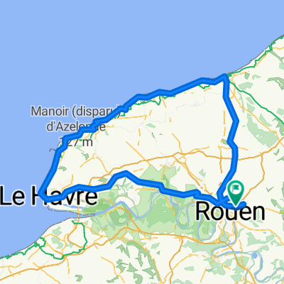
forêt verte
A cycling route starting in Bois-Guillaume, Normandy, France.
Overview
About this route
- 3 h 51 min
- Duration
- 25.7 km
- Distance
- 243 m
- Ascent
- 246 m
- Descent
- 6.7 km/h
- Avg. speed
- ---
- Max. altitude

Continue with Bikemap
Use, edit, or download this cycling route
You would like to ride forêt verte or customize it for your own trip? Here is what you can do with this Bikemap route:
Free features
- Save this route as favorite or in collections
- Copy & plan your own version of this route
- Sync your route with Garmin or Wahoo
Premium features
Free trial for 3 days, or one-time payment. More about Bikemap Premium.
- Navigate this route on iOS & Android
- Export a GPX / KML file of this route
- Create your custom printout (try it for free)
- Download this route for offline navigation
Discover more Premium features.
Get Bikemap PremiumFrom our community
Other popular routes starting in Bois-Guillaume
 rouen clecy
- Distance
- 391.9 km
- Ascent
- 1,098 m
- Descent
- 1,098 m
- Location
- Bois-Guillaume, Normandy, France
 Rouen - Coutence
- Distance
- 271.4 km
- Ascent
- 1,096 m
- Descent
- 1,119 m
- Location
- Bois-Guillaume, Normandy, France
 rouen moustiers mt ventoux
- Distance
- 1,047.8 km
- Ascent
- 2,539 m
- Descent
- 2,069 m
- Location
- Bois-Guillaume, Normandy, France
 De 72 Allée Gabriel Reuillard, Bois-Guillaume à 72 Allée Gabriel Reuillard, Bois-Guillaume
- Distance
- 22.8 km
- Ascent
- 456 m
- Descent
- 457 m
- Location
- Bois-Guillaume, Normandy, France
 rouen-dieppe-fecamp-etretat-rouen
- Distance
- 265.8 km
- Ascent
- 777 m
- Descent
- 928 m
- Location
- Bois-Guillaume, Normandy, France
 Rouen Paris Rouen
- Distance
- 280.9 km
- Ascent
- 1,114 m
- Descent
- 1,114 m
- Location
- Bois-Guillaume, Normandy, France
 forêt verte
- Distance
- 25.7 km
- Ascent
- 243 m
- Descent
- 246 m
- Location
- Bois-Guillaume, Normandy, France
 rouen le havre dieppe
- Distance
- 299.4 km
- Ascent
- 1,107 m
- Descent
- 1,106 m
- Location
- Bois-Guillaume, Normandy, France
Open it in the app