

Von Marienstein zum Tegernsee (Gut Kaltenbrunn)
A cycling route starting in Waakirchen, Bavaria, Germany.
Overview
About this route
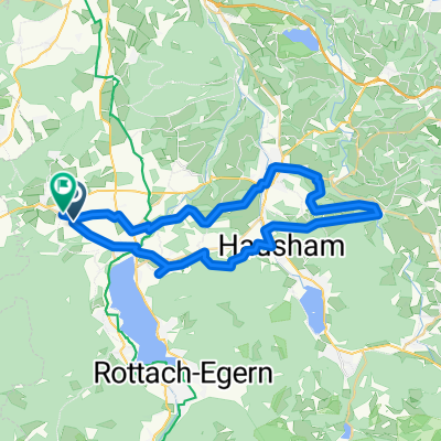
From Marienstein to Tegernsee (Gut Kaltenbrunn)
- -:--
- Duration
- 5.3 km
- Distance
- 84 m
- Ascent
- 148 m
- Descent
- ---
- Avg. speed
- 871 m
- Max. altitude
Route quality
Waytypes & surfaces along the route
Waytypes
Quiet road
3.3 km
(63 %)
Track
1.4 km
(26 %)
Surfaces
Paved
4.4 km
(84 %)
Unpaved
0.3 km
(6 %)
Asphalt
4.4 km
(84 %)
Unpaved (undefined)
0.3 km
(5 %)
Continue with Bikemap
Use, edit, or download this cycling route
You would like to ride Von Marienstein zum Tegernsee (Gut Kaltenbrunn) or customize it for your own trip? Here is what you can do with this Bikemap route:
Free features
- Save this route as favorite or in collections
- Copy & plan your own version of this route
- Sync your route with Garmin or Wahoo
Premium features
Free trial for 3 days, or one-time payment. More about Bikemap Premium.
- Navigate this route on iOS & Android
- Export a GPX / KML file of this route
- Create your custom printout (try it for free)
- Download this route for offline navigation
Discover more Premium features.
Get Bikemap PremiumFrom our community
Other popular routes starting in Waakirchen
 Waa_Aga_Wörn_MB_Moo_Waa
- Distance
- 45.8 km
- Ascent
- 848 m
- Descent
- 839 m
- Location
- Waakirchen, Bavaria, Germany
 Waakirchen-Lenggries-Bad Tölz
- Distance
- 45.4 km
- Ascent
- 278 m
- Descent
- 278 m
- Location
- Waakirchen, Bavaria, Germany
 Hauptstraße 32, Waakirchen nach Hauptstraße 32, Waakirchen
- Distance
- 82.8 km
- Ascent
- 908 m
- Descent
- 907 m
- Location
- Waakirchen, Bavaria, Germany
 Kloster Reutberg Waakirchen
- Distance
- 18.8 km
- Ascent
- 110 m
- Descent
- 104 m
- Location
- Waakirchen, Bavaria, Germany
 Miesbach ; Teggernsee , Schliersee , Tatzlwurm
- Distance
- 106.5 km
- Ascent
- 1,273 m
- Descent
- 1,354 m
- Location
- Waakirchen, Bavaria, Germany
 Hauserdörfel Aueralm Hirschbachsattel Lenggries CLONED FROM ROUTE 721522
- Distance
- 47.5 km
- Ascent
- 1,189 m
- Descent
- 1,186 m
- Location
- Waakirchen, Bavaria, Germany
 Lanserhof - Hainzenhöhe
- Distance
- 7.4 km
- Ascent
- 150 m
- Descent
- 148 m
- Location
- Waakirchen, Bavaria, Germany
 Von Marienstein auf den Wallberg
- Distance
- 27.7 km
- Ascent
- 761 m
- Descent
- 436 m
- Location
- Waakirchen, Bavaria, Germany
Open it in the app