

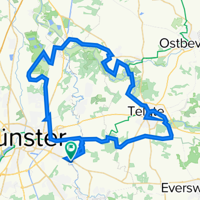
Münster - Rheine (+Bahnradweg)
A cycling route starting in Münster, North Rhine-Westphalia, Germany.
Overview
About this route
Von MS über Voßkotten, Hollingen, Ahlintel, St. Arnold, Bahnradweg, Hauenhorst und den Waldhügel nach Rheine
- -:--
- Duration
- 51 km
- Distance
- 71 m
- Ascent
- 78 m
- Descent
- ---
- Avg. speed
- 70 m
- Avg. speed
Route quality
Waytypes & surfaces along the route
Waytypes
Quiet road
25 km
(49 %)
Path
12.7 km
(25 %)
Surfaces
Paved
45.8 km
(90 %)
Unpaved
0.8 km
(2 %)
Asphalt
40.9 km
(80 %)
Paving stones
2.5 km
(5 %)
Continue with Bikemap
Use, edit, or download this cycling route
You would like to ride Münster - Rheine (+Bahnradweg) or customize it for your own trip? Here is what you can do with this Bikemap route:
Free features
- Save this route as favorite or in collections
- Copy & plan your own version of this route
- Sync your route with Garmin or Wahoo
Premium features
Free trial for 3 days, or one-time payment. More about Bikemap Premium.
- Navigate this route on iOS & Android
- Export a GPX / KML file of this route
- Create your custom printout (try it for free)
- Download this route for offline navigation
Discover more Premium features.
Get Bikemap PremiumFrom our community
Other popular routes starting in Münster
 Campingplatz - Emsauen- u. Kanal-Tour
- Distance
- 53.2 km
- Ascent
- 182 m
- Descent
- 179 m
- Location
- Münster, North Rhine-Westphalia, Germany
 Samstagnachmittagsrunde: 117 km Teuto/Schafberg
- Distance
- 117.5 km
- Ascent
- 635 m
- Descent
- 651 m
- Location
- Münster, North Rhine-Westphalia, Germany
 Giro 2010 55km
- Distance
- 56 km
- Ascent
- 238 m
- Descent
- 242 m
- Location
- Münster, North Rhine-Westphalia, Germany
 Mittlere Trainingsrunde im Osten Münsters
- Distance
- 56.3 km
- Ascent
- 61 m
- Descent
- 67 m
- Location
- Münster, North Rhine-Westphalia, Germany
 Erste Münsterland Giro.2011 Erkundungstour
- Distance
- 66.9 km
- Ascent
- 54 m
- Descent
- 54 m
- Location
- Münster, North Rhine-Westphalia, Germany
 Kurze Münsterlandrunde
- Distance
- 38.7 km
- Ascent
- 109 m
- Descent
- 109 m
- Location
- Münster, North Rhine-Westphalia, Germany
 Baumbergekurztrip
- Distance
- 54.4 km
- Ascent
- 207 m
- Descent
- 208 m
- Location
- Münster, North Rhine-Westphalia, Germany
 Hohe Ward Rundweg
- Distance
- 36.9 km
- Ascent
- 49 m
- Descent
- 48 m
- Location
- Münster, North Rhine-Westphalia, Germany
Open it in the app