
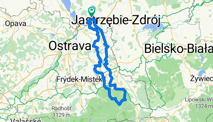
Turza Śl.-Beskid
A cycling route starting in Turza Śląska, Silesian Voivodeship, Poland.
Overview
About this route
- -:--
- Duration
- 141.6 km
- Distance
- 1,087 m
- Ascent
- 1,094 m
- Descent
- ---
- Avg. speed
- ---
- Max. altitude

Route quality
Waytypes & surfaces along the route
Waytypes
Quiet road
58 km
(41 %)
Road
27.6 km
(19 %)
Surfaces
Paved
59.4 km
(42 %)
Unpaved
13.9 km
(10 %)
Asphalt
48.3 km
(34 %)
Paved (undefined)
9.3 km
(7 %)
Continue with Bikemap
Use, edit, or download this cycling route
You would like to ride Turza Śl.-Beskid or customize it for your own trip? Here is what you can do with this Bikemap route:
Free features
- Save this route as favorite or in collections
- Copy & plan your own version of this route
- Split it into stages to create a multi-day tour
- Sync your route with Garmin or Wahoo
Premium features
Free trial for 3 days, or one-time payment. More about Bikemap Premium.
- Navigate this route on iOS & Android
- Export a GPX / KML file of this route
- Create your custom printout (try it for free)
- Download this route for offline navigation
Discover more Premium features.
Get Bikemap PremiumFrom our community
Other popular routes starting in Turza Śląska
 Bogumińska 5A, Turza Śląska to Ostravská, Bohumín
- Distance
- 24.3 km
- Ascent
- 124 m
- Descent
- 194 m
- Location
- Turza Śląska, Silesian Voivodeship, Poland
 Asfalty 3
- Distance
- 46.5 km
- Ascent
- 289 m
- Descent
- 249 m
- Location
- Turza Śląska, Silesian Voivodeship, Poland
 czechy 77km
- Distance
- 77.1 km
- Ascent
- 314 m
- Descent
- 304 m
- Location
- Turza Śląska, Silesian Voivodeship, Poland
 Turza-Konczyce 60km
- Distance
- 60.2 km
- Ascent
- 349 m
- Descent
- 351 m
- Location
- Turza Śląska, Silesian Voivodeship, Poland
 Graniczna 23, Turza Śląska do Graniczna 23, Turza Śląska
- Distance
- 50.6 km
- Ascent
- 423 m
- Descent
- 423 m
- Location
- Turza Śląska, Silesian Voivodeship, Poland
 Turza Śl.-Beskid
- Distance
- 141.6 km
- Ascent
- 1,087 m
- Descent
- 1,094 m
- Location
- Turza Śląska, Silesian Voivodeship, Poland
 Czyżowice SWD
- Distance
- 67.6 km
- Ascent
- 367 m
- Descent
- 349 m
- Location
- Turza Śląska, Silesian Voivodeship, Poland
 Czyżowice - Český Těšín
- Distance
- 33.8 km
- Ascent
- 148 m
- Descent
- 92 m
- Location
- Turza Śląska, Silesian Voivodeship, Poland
Open it in the app