

LocalBBT
BikeLane-WatTonChuek-Horse'NCoffee-K9
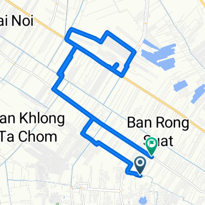
A cycling route starting in Bang Bua Thong, Nonthaburi, Thailand.
Overview
About this route
ส่วนมากจะปั่นเลียบถนนเล็กๆ และคลองประปา คลองบ้านกล้วย ช่วงขาไปและกลับจะมีออกถนนกาญจนาภิเษกบ้าง เพราะจุดตั้งต้นและจุดสิ้นสุดคือ BikeLaneShop ที่อยู่ตรงข้ามสมบัติบุรี
- -:--
- Duration
- 58.1 km
- Distance
- 8 m
- Ascent
- 12 m
- Descent
- ---
- Avg. speed
- ---
- Max. altitude

Part of
LocalBBT
2 stages
Route quality
Waytypes & surfaces along the route
Waytypes
Quiet road
22.1 km
(38 %)
Road
20.9 km
(36 %)
Surfaces
Paved
8.7 km
(15 %)
Paved (undefined)
5.8 km
(10 %)
Asphalt
1.7 km
(3 %)
Continue with Bikemap
Use, edit, or download this cycling route
You would like to ride BikeLane-WatTonChuek-Horse'NCoffee-K9 or customize it for your own trip? Here is what you can do with this Bikemap route:
Free features
- Save this route as favorite or in collections
- Copy & plan your own version of this route
- Sync your route with Garmin or Wahoo
Premium features
Free trial for 3 days, or one-time payment. More about Bikemap Premium.
- Navigate this route on iOS & Android
- Export a GPX / KML file of this route
- Create your custom printout (try it for free)
- Download this route for offline navigation
Discover more Premium features.
Get Bikemap PremiumFrom our community
Other popular routes starting in Bang Bua Thong
 ถนน บางกรวย - ไทรน้อย 59, ตำบลโสนลอย to ถนน บางศรีเมือง 50/66
- Distance
- 17.6 km
- Ascent
- 42 m
- Descent
- 41 m
- Location
- Bang Bua Thong, Nonthaburi, Thailand
 Quick bike tour from (null) to (null)
- Distance
- 8.7 km
- Ascent
- 9 m
- Descent
- 8 m
- Location
- Bang Bua Thong, Nonthaburi, Thailand
 ตำบล พิมลราช to ตำบล พิมลราช
- Distance
- 18.3 km
- Ascent
- 23 m
- Descent
- 22 m
- Location
- Bang Bua Thong, Nonthaburi, Thailand
 ประเทศไทย, ตำบล ละหาร to ตำบล บึงบอน
- Distance
- 50.7 km
- Ascent
- 258 m
- Descent
- 260 m
- Location
- Bang Bua Thong, Nonthaburi, Thailand
 เกาะเกร็ด
- Distance
- 27.8 km
- Ascent
- 14 m
- Descent
- 17 m
- Location
- Bang Bua Thong, Nonthaburi, Thailand
 ซอย หมู่บ้านบัวทองแลนด์ ซอย 3/10 89/32, ตำบล บางบัวทอง to ซอย หมู่บ้านบัวทองแลนด์ ซอย 3/10 89/32, ตำบล บางบัวทอง
- Distance
- 0.1 km
- Ascent
- 0 m
- Descent
- 29 m
- Location
- Bang Bua Thong, Nonthaburi, Thailand
 Mini Audec 2019
- Distance
- 45.1 km
- Ascent
- 17 m
- Descent
- 24 m
- Location
- Bang Bua Thong, Nonthaburi, Thailand
 MyMapCycling
- Distance
- 127.6 km
- Ascent
- 8 m
- Descent
- 8 m
- Location
- Bang Bua Thong, Nonthaburi, Thailand
Open it in the app