מעלות תרשיחא-מונפורט-עין יעקב-כברי-כפר ורדים
A cycling route starting in Ma'alot-Tarshiha, Northern District, Israel.
Overview
About this route
אורך:43 ק"מ
גובה: 830 מטר
תאור: אחוזת אסיינדה, אגם מונפורט, חזרה לכביש 89, צפונה, תרשיחא, כביש 8833, עין יעקב, געתון, שמאלה בכביש 89, צומת כברי, כביש 70, שמאלה 8721, ג'את, ינוח, כפר ורדים, שמאלה ב- 89
- -:--
- Duration
- 42.9 km
- Distance
- 827 m
- Ascent
- 825 m
- Descent
- ---
- Avg. speed
- ---
- Max. altitude
Continue with Bikemap
Use, edit, or download this cycling route
You would like to ride מעלות תרשיחא-מונפורט-עין יעקב-כברי-כפר ורדים or customize it for your own trip? Here is what you can do with this Bikemap route:
Free features
- Save this route as favorite or in collections
- Copy & plan your own version of this route
- Sync your route with Garmin or Wahoo
Premium features
Free trial for 3 days, or one-time payment. More about Bikemap Premium.
- Navigate this route on iOS & Android
- Export a GPX / KML file of this route
- Create your custom printout (try it for free)
- Download this route for offline navigation
Discover more Premium features.
Get Bikemap PremiumFrom our community
Other popular routes starting in Ma'alot-Tarshiha
- כפר ורדים, יחיעם, עין יעקב, געתון מעונה, עידן פטשניק
- Distance
- 25.8 km
- Ascent
- 623 m
- Descent
- 597 m
- Location
- Ma'alot-Tarshiha, Northern District, Israel
- нахаль ахзив
- Distance
- 16.1 km
- Ascent
- 33 m
- Descent
- 203 m
- Location
- Ma'alot-Tarshiha, Northern District, Israel
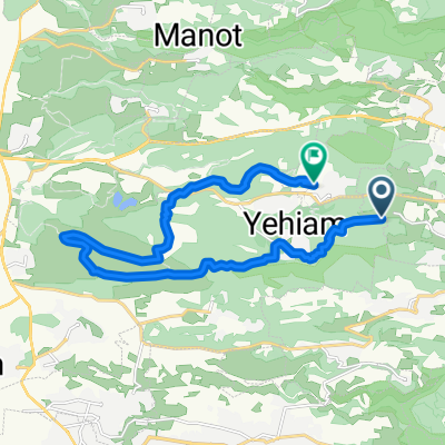
- Route from הצבעוני 14 א, מעלות תרשיחא
- Distance
- 28.4 km
- Ascent
- 123 m
- Descent
- 610 m
- Location
- Ma'alot-Tarshiha, Northern District, Israel
- חצב 60, כפר ורדים to הדס 15, כפר ורדים
- Distance
- 4.4 km
- Ascent
- 46 m
- Descent
- 63 m
- Location
- Ma'alot-Tarshiha, Northern District, Israel
- Lengthy bike tour through Maalot Tarshiha
- Distance
- 45.8 km
- Ascent
- 788 m
- Descent
- 796 m
- Location
- Ma'alot-Tarshiha, Northern District, Israel
- ride from Maalot Tarshiha to Naaharia
- Distance
- 27.5 km
- Ascent
- 43 m
- Descent
- 500 m
- Location
- Ma'alot-Tarshiha, Northern District, Israel
- Me'ona Junction to Unnamed Road
- Distance
- 10 km
- Ascent
- 331 m
- Descent
- 594 m
- Location
- Ma'alot-Tarshiha, Northern District, Israel
- מעלות תרשיחא-מונפורט-עין יעקב-כברי-כפר ורדים
- Distance
- 42.9 km
- Ascent
- 827 m
- Descent
- 825 m
- Location
- Ma'alot-Tarshiha, Northern District, Israel
Open it in the app