

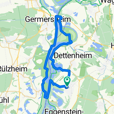
Rund um die untere Hardt 2021 - 72 km Permanente des RV Badenia Linkenheim 1900 e.V.
A cycling route starting in Linkenheim-Hochstetten, Baden-Wurttemberg, Germany.
Overview
About this route
Rund um die untere Hardt 2021 - 72 km
Permanent RTF of the RV Badenia Linkenheim 1900 e.V.
All further information about this route – click here
- -:--
- Duration
- 69.1 km
- Distance
- 60 m
- Ascent
- 59 m
- Descent
- ---
- Avg. speed
- ---
- Max. altitude

Route quality
Waytypes & surfaces along the route
Waytypes
Road
27.6 km
(40 %)
Path
14.5 km
(21 %)
Surfaces
Paved
66.3 km
(96 %)
Unpaved
0.7 km
(1 %)
Asphalt
62.8 km
(91 %)
Paved (undefined)
3.5 km
(5 %)
Continue with Bikemap
Use, edit, or download this cycling route
You would like to ride Rund um die untere Hardt 2021 - 72 km Permanente des RV Badenia Linkenheim 1900 e.V. or customize it for your own trip? Here is what you can do with this Bikemap route:
Free features
- Save this route as favorite or in collections
- Copy & plan your own version of this route
- Sync your route with Garmin or Wahoo
Premium features
Free trial for 3 days, or one-time payment. More about Bikemap Premium.
- Navigate this route on iOS & Android
- Export a GPX / KML file of this route
- Create your custom printout (try it for free)
- Download this route for offline navigation
Discover more Premium features.
Get Bikemap PremiumFrom our community
Other popular routes starting in Linkenheim-Hochstetten
 route66
- Distance
- 37.4 km
- Ascent
- 50 m
- Descent
- 49 m
- Location
- Linkenheim-Hochstetten, Baden-Wurttemberg, Germany
 Rhein-Kraichgau-Rhein 2017 - RTF des RV Badenia Linkenheim 1900 e.V. - 111 km Strecke
- Distance
- 101.5 km
- Ascent
- 559 m
- Descent
- 559 m
- Location
- Linkenheim-Hochstetten, Baden-Wurttemberg, Germany
 An der Bahn 17, Linkenheim-Hochstetten nach An der Bahn 17, Linkenheim-Hochstetten
- Distance
- 24.3 km
- Ascent
- 22 m
- Descent
- 71 m
- Location
- Linkenheim-Hochstetten, Baden-Wurttemberg, Germany
 Vom Rhein an den Schwarzwald - RTF des RV Badenia Linkenheim 1900 e.V. - 77 km Strecke
- Distance
- 76.1 km
- Ascent
- 396 m
- Descent
- 396 m
- Location
- Linkenheim-Hochstetten, Baden-Wurttemberg, Germany
 Vom Rhein zum Schwarzwald 2017 - Marathon des RV Badenia Linkenheim 1900 e.V. - 208 km Strecke
- Distance
- 199.6 km
- Ascent
- 1,397 m
- Descent
- 1,398 m
- Location
- Linkenheim-Hochstetten, Baden-Wurttemberg, Germany
 Ungeheuerklamm-Trail
- Distance
- 45.7 km
- Ascent
- 383 m
- Descent
- 382 m
- Location
- Linkenheim-Hochstetten, Baden-Wurttemberg, Germany
 Elisabethenwört_1
- Distance
- 8.3 km
- Ascent
- 39 m
- Descent
- 39 m
- Location
- Linkenheim-Hochstetten, Baden-Wurttemberg, Germany
 Vom Rhein an den Schwarzwald - RTF des RV Badenia Linkenheim 1900 e.V. - 119 km Strecke
- Distance
- 107.9 km
- Ascent
- 711 m
- Descent
- 711 m
- Location
- Linkenheim-Hochstetten, Baden-Wurttemberg, Germany
Open it in the app