

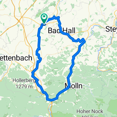
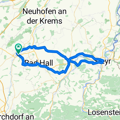
Kremsmünster - Sipbachzell - Sattledt - Kremsmünster
A cycling route starting in Kremsmünster, Upper Austria, Austria.
Overview
About this route
- -:--
- Duration
- 27.8 km
- Distance
- 185 m
- Ascent
- 218 m
- Descent
- ---
- Avg. speed
- 441 m
- Max. altitude

Route quality
Waytypes & surfaces along the route
Waytypes
Quiet road
22.3 km
(80 %)
Track
2.8 km
(10 %)
Surfaces
Paved
1.1 km
(4 %)
Unpaved
4.2 km
(15 %)
Unpaved (undefined)
2.2 km
(8 %)
Gravel
1.4 km
(5 %)
Route highlights
Points of interest along the route
Point of interest after 16.1 km
Mostheuriger Spörer
Continue with Bikemap
Use, edit, or download this cycling route
You would like to ride Kremsmünster - Sipbachzell - Sattledt - Kremsmünster or customize it for your own trip? Here is what you can do with this Bikemap route:
Free features
- Save this route as favorite or in collections
- Copy & plan your own version of this route
- Sync your route with Garmin or Wahoo
Premium features
Free trial for 3 days, or one-time payment. More about Bikemap Premium.
- Navigate this route on iOS & Android
- Export a GPX / KML file of this route
- Create your custom printout (try it for free)
- Download this route for offline navigation
Discover more Premium features.
Get Bikemap PremiumFrom our community
Other popular routes starting in Kremsmünster
 Von Kremsmünster bis Wartberg an der Krems
- Distance
- 68.7 km
- Ascent
- 768 m
- Descent
- 744 m
- Location
- Kremsmünster, Upper Austria, Austria
 Filialkirche Weigersdorf – Krems Runde von Kremsmünster 🚶♀️🚶♂️
- Distance
- 58.9 km
- Ascent
- 1,056 m
- Descent
- 1,057 m
- Location
- Kremsmünster, Upper Austria, Austria
 Kremsmünster - Runde
- Distance
- 78.2 km
- Ascent
- 836 m
- Descent
- 837 m
- Location
- Kremsmünster, Upper Austria, Austria
 Sehr schöner Weitblick – die Krems Runde von Kremsmünster. 🚴🚴♂️
- Distance
- 51.3 km
- Ascent
- 755 m
- Descent
- 757 m
- Location
- Kremsmünster, Upper Austria, Austria
 Krems - Steyrtal
- Distance
- 76.6 km
- Ascent
- 291 m
- Descent
- 294 m
- Location
- Kremsmünster, Upper Austria, Austria
 Rettenpacherweg, Kremsmünster nach Rettenpacherweg, Kremsmünster
- Distance
- 64.7 km
- Ascent
- 750 m
- Descent
- 749 m
- Location
- Kremsmünster, Upper Austria, Austria
 Krift - Scheiben - Feyregg - Diepersdorf - Nußbach - Schlierbach - Wartberg - Krift
- Distance
- 46.5 km
- Ascent
- 826 m
- Descent
- 825 m
- Location
- Kremsmünster, Upper Austria, Austria
 Sipbachzell - Magdalenaberg
- Distance
- 50.9 km
- Ascent
- 395 m
- Descent
- 395 m
- Location
- Kremsmünster, Upper Austria, Austria
Open it in the app