

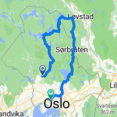
Frognerseteren - Skjennungen - Ullevålseter - Sognsvann
A cycling route starting in Sjølyststranda, Oslo County, Norway.
Overview
About this route
- -:--
- Duration
- 11.3 km
- Distance
- 0 m
- Ascent
- 0 m
- Descent
- ---
- Avg. speed
- ---
- Max. altitude

Route quality
Waytypes & surfaces along the route
Waytypes
Track
5.8 km
(51 %)
Quiet road
3.5 km
(31 %)
Access road
2 km
(18 %)
Surfaces
Paved
0.3 km
(3 %)
Unpaved
11.1 km
(98 %)
Gravel
9.5 km
(84 %)
Woodchips
0.9 km
(8 %)
Continue with Bikemap
Use, edit, or download this cycling route
You would like to ride Frognerseteren - Skjennungen - Ullevålseter - Sognsvann or customize it for your own trip? Here is what you can do with this Bikemap route:
Free features
- Save this route as favorite or in collections
- Copy & plan your own version of this route
- Sync your route with Garmin or Wahoo
Premium features
Free trial for 3 days, or one-time payment. More about Bikemap Premium.
- Navigate this route on iOS & Android
- Export a GPX / KML file of this route
- Create your custom printout (try it for free)
- Download this route for offline navigation
Discover more Premium features.
Get Bikemap PremiumFrom our community
Other popular routes starting in Sjølyststranda
 Brønnøya
- Distance
- 18.3 km
- Ascent
- 95 m
- Descent
- 178 m
- Location
- Sjølyststranda, Oslo County, Norway
 Voksenkollen-Koksrud 🚴🏻♂️🐗💨😅
- Distance
- 62.8 km
- Ascent
- 1,779 m
- Descent
- 2,154 m
- Location
- Sjølyststranda, Oslo County, Norway
 Gabels Gate 14, Oslo to Drammensveien 61B, Oslo
- Distance
- 73.8 km
- Ascent
- 89 m
- Descent
- 106 m
- Location
- Sjølyststranda, Oslo County, Norway
 Oppkuven rundt
- Distance
- 37.6 km
- Ascent
- 515 m
- Descent
- 515 m
- Location
- Sjølyststranda, Oslo County, Norway
 sognsvann-bånntjern-vettakollen-skjennung-ullevålseter-svartkulp
- Distance
- 16.7 km
- Ascent
- 368 m
- Descent
- 370 m
- Location
- Sjølyststranda, Oslo County, Norway
 Movatn long
- Distance
- 54.3 km
- Ascent
- 792 m
- Descent
- 1,205 m
- Location
- Sjølyststranda, Oslo County, Norway
 Oslo/Maridalen/Hakloa/Trehjørningen/Greveveien
- Distance
- 66.1 km
- Ascent
- 600 m
- Descent
- 600 m
- Location
- Sjølyststranda, Oslo County, Norway
 sørkedalen
- Distance
- 23 km
- Ascent
- 327 m
- Descent
- 327 m
- Location
- Sjølyststranda, Oslo County, Norway
Open it in the app