
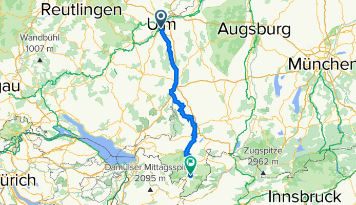
Ulm-Oberstdorf
A cycling route starting in Neu-Ulm, Bavaria, Germany.
Overview
About this route
Umsonst parken kann man Nähe Friedrichsau/Ulm, an der Illerbrücke kurz vor Wiblingen... oder, bei Rückfahrt von Oberstdorf mit der Bahn, in Illertissen/Bahnhof (bei Kauf eines Bahntickets ist Parken dort umsonst und sehr verkehrsgünstig). Illerradweg war sehr schön zu fahren (bis auf einige baustellenbedingte Umleitungen, die manchmal irgendwo endeten und man selber schauen durfte, wie es zurück zur Iller ging). Ich wählte, der schöneren Aussichten auf die Berge wegen, die Fahrtrichtung Ulm-Oberstdorf. Diese Strecke ist locker an einem Tag zu schaffen (ca. 12 Stunden, incl. Pausen und Abstecher Illerschleife/-durchbruch + Kempten).
- -:--
- Duration
- 149.2 km
- Distance
- 569 m
- Ascent
- 240 m
- Descent
- ---
- Avg. speed
- ---
- Max. altitude

Route quality
Waytypes & surfaces along the route
Waytypes
Track
67.2 km
(45 %)
Quiet road
28.4 km
(19 %)
Surfaces
Paved
35.8 km
(24 %)
Unpaved
95.5 km
(64 %)
Gravel
82.1 km
(55 %)
Asphalt
35.8 km
(24 %)
Continue with Bikemap
Use, edit, or download this cycling route
You would like to ride Ulm-Oberstdorf or customize it for your own trip? Here is what you can do with this Bikemap route:
Free features
- Save this route as favorite or in collections
- Copy & plan your own version of this route
- Split it into stages to create a multi-day tour
- Sync your route with Garmin or Wahoo
Premium features
Free trial for 3 days, or one-time payment. More about Bikemap Premium.
- Navigate this route on iOS & Android
- Export a GPX / KML file of this route
- Create your custom printout (try it for free)
- Download this route for offline navigation
Discover more Premium features.
Get Bikemap PremiumFrom our community
Other popular routes starting in Neu-Ulm
 BRT2012-MI: Drei-Täler-Tour - RTF des BRT2012 in Ulm - 103 km Strecke
- Distance
- 126 km
- Ascent
- 611 m
- Descent
- 610 m
- Location
- Neu-Ulm, Bavaria, Germany
 BRT2012-MI: Drei-Täler-Tour - RTF des BRT2012 in Ulm - 72 km Strecke
- Distance
- 87.9 km
- Ascent
- 567 m
- Descent
- 567 m
- Location
- Neu-Ulm, Bavaria, Germany
 3.Tag 17.07. Ulm nach Blaubeuern nach Ulm
- Distance
- 46.6 km
- Ascent
- 312 m
- Descent
- 312 m
- Location
- Neu-Ulm, Bavaria, Germany
 Feierabend-Tour MTB Ulm
- Distance
- 30.4 km
- Ascent
- 501 m
- Descent
- 498 m
- Location
- Neu-Ulm, Bavaria, Germany
 BRT2012-FR: Über die Alb und entlang des Kliffs - RTF des BRT2012 in Ulm - 107 km Strecke
- Distance
- 102.8 km
- Ascent
- 525 m
- Descent
- 525 m
- Location
- Neu-Ulm, Bavaria, Germany
 BRT2012-DO: Zwischen Iller und Rot - RTF des BRT2012 in Ulm - 71 km Strecke
- Distance
- 71.5 km
- Ascent
- 209 m
- Descent
- 209 m
- Location
- Neu-Ulm, Bavaria, Germany
 BRT2012-FR: Über die Alb und entlang des Kliffs - RTF des BRT2012 in Ulm - 72 km Strecke
- Distance
- 68.2 km
- Ascent
- 394 m
- Descent
- 394 m
- Location
- Neu-Ulm, Bavaria, Germany
 Radtour P15 25.06.2011
- Distance
- 64.9 km
- Ascent
- 246 m
- Descent
- 246 m
- Location
- Neu-Ulm, Bavaria, Germany
Open it in the app