

Kábul - Dháka
A cycling route starting in Kabul, Kabul, Afghanistan.
Overview
About this route
- -:--
- Duration
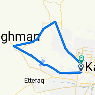
- 3,111.2 km
- Distance
- 1,015 m
- Ascent
- 2,804 m
- Descent
- ---
- Avg. speed
- ---
- Max. altitude

Continue with Bikemap
Use, edit, or download this cycling route
You would like to ride Kábul - Dháka or customize it for your own trip? Here is what you can do with this Bikemap route:
Free features
- Save this route as favorite or in collections
- Copy & plan your own version of this route
- Split it into stages to create a multi-day tour
- Sync your route with Garmin or Wahoo
Premium features
Free trial for 3 days, or one-time payment. More about Bikemap Premium.
- Navigate this route on iOS & Android
- Export a GPX / KML file of this route
- Create your custom printout (try it for free)
- Download this route for offline navigation
Discover more Premium features.
Get Bikemap PremiumFrom our community
Other popular routes starting in Kabul
 Steady ride in کابل
- Distance
- 47.6 km
- Ascent
- 670 m
- Descent
- 674 m
- Location
- Kabul, Kabul, Afghanistan
 Service Road, Kabol to سرگ سالنگ, Kabol
- Distance
- 42.5 km
- Ascent
- 569 m
- Descent
- 584 m
- Location
- Kabul, Kabul, Afghanistan
 Kábul - Dháka
- Distance
- 3,111.2 km
- Ascent
- 1,015 m
- Descent
- 2,804 m
- Location
- Kabul, Kabul, Afghanistan
 Esteolal Road, Kabol to Unnamed Road, Kabol
- Distance
- 16.5 km
- Ascent
- 53 m
- Descent
- 60 m
- Location
- Kabul, Kabul, Afghanistan
 Recovered Route
- Distance
- 19.2 km
- Ascent
- 373 m
- Descent
- 171 m
- Location
- Kabul, Kabul, Afghanistan
 Flag Tapa
- Distance
- 21 km
- Ascent
- 7,021 m
- Descent
- 7,033 m
- Location
- Kabul, Kabul, Afghanistan
 xourse
- Distance
- 4.9 km
- Ascent
- 69 m
- Descent
- 53 m
- Location
- Kabul, Kabul, Afghanistan
 High-speed route
- Distance
- 45.3 km
- Ascent
- 423 m
- Descent
- 392 m
- Location
- Kabul, Kabul, Afghanistan
Open it in the app