

Latscher Trail Zauber S2 (klein)
A cycling route starting in Latsch, Trentino-Alto Adige, Italy.
Overview
About this route
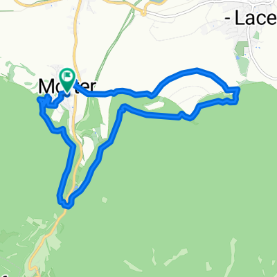
Great trail loop with Waal and ruin experience as well as apple flair on the southern woodland edge of Latsch. From the AquaForum, the gravel path climbs a few meters over Rehpromenade and Trimm-Dich-Pfad up to the storage pond of the irrigation systems. Before the bridge, turning right, the undulating trail winds through the cool forest along the Jägersteig and Neuwaal to Obermontani Castle Ruins. The transition between pedaling sections and a light downhill flow challenges technical riding skills repeatedly. At the Obermontani Castle Ruins, a wonderful view and the famous St. Stephan chapel with its frescoes await us. From here, a fine switchback trail beckons the techies until we return on relatively level roads and the Mareinwaal. A cold beer and good food are available along the way at the beer cellar, the pizzeria in the AquaForum, or in Latsch. Note: Many Share The Trail sections! Descent or connection options: Shortly after the bike path below Obermontani, turn left towards Morter and via the Morterer Leger-Tour to the entrance of the 2/3 trail or up to the Holy Hansen Trail.
- -:--
- Duration
- 11.1 km
- Distance
- 388 m
- Ascent
- 394 m
- Descent
- ---
- Avg. speed
- ---
- Max. altitude

Continue with Bikemap
Use, edit, or download this cycling route
You would like to ride Latscher Trail Zauber S2 (klein) or customize it for your own trip? Here is what you can do with this Bikemap route:
Free features
- Save this route as favorite or in collections
- Copy & plan your own version of this route
- Sync your route with Garmin or Wahoo
Premium features
Free trial for 3 days, or one-time payment. More about Bikemap Premium.
- Navigate this route on iOS & Android
- Export a GPX / KML file of this route
- Create your custom printout (try it for free)
- Download this route for offline navigation
Discover more Premium features.
Get Bikemap PremiumFrom our community
Other popular routes starting in Latsch
 Freiberger Alm, leicht
- Distance
- 15.2 km
- Ascent
- 947 m
- Descent
- 925 m
- Location
- Latsch, Trentino-Alto Adige, Italy
 Tschili Trail St.Martin
- Distance
- 8.6 km
- Ascent
- 0 m
- Descent
- 1,103 m
- Location
- Latsch, Trentino-Alto Adige, Italy
 4er Trail Latscher Alm
- Distance
- 25.1 km
- Ascent
- 1,200 m
- Descent
- 1,200 m
- Location
- Latsch, Trentino-Alto Adige, Italy
 an_den_alten_waalwassern_179644249
- Distance
- 10.2 km
- Ascent
- 180 m
- Descent
- 168 m
- Location
- Latsch, Trentino-Alto Adige, Italy
 TP 05 Latsch-Naturns Bahnhofstrasse-St.Walburg (50,23km)
- Distance
- 50.2 km
- Ascent
- 1,767 m
- Descent
- 1,276 m
- Location
- Latsch, Trentino-Alto Adige, Italy
 Laces-Bormio
- Distance
- 72.3 km
- Ascent
- 2,159 m
- Descent
- 1,595 m
- Location
- Latsch, Trentino-Alto Adige, Italy
 Latsch - Meran
- Distance
- 27.1 km
- Ascent
- 296 m
- Descent
- 273 m
- Location
- Latsch, Trentino-Alto Adige, Italy
 Latsch Propain Trail Runde S2-S3
- Distance
- 33 km
- Ascent
- 1,291 m
- Descent
- 1,289 m
- Location
- Latsch, Trentino-Alto Adige, Italy
Open it in the app