

Uphill Marzoner Alm 2
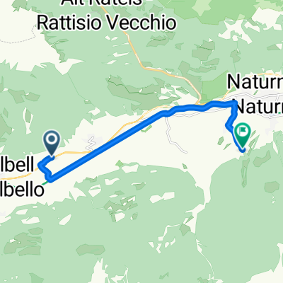
A cycling route starting in Castelbello, Trentino-Alto Adige, Italy.
Overview
About this route
Die gemütlichere Variante zur urigen Marzoner Alm. Von der rauschenden Etsch beim Hotel Winkler in Tschars führt der Uphill Marzoner Alm 2 südlich über die Etschbrücke erst flach durch schöne Apfelgärten und dann immer in angenehmer Steigung auf Asphalt an den wunderbaren Höfen vorbei zum Tomberg. An der Kreuzung Zirmtal zweigt man nach rechts ab und erreicht über einen weiteren Anstieg die auf einer Wiese am Waldesrand gelegene Marzoner Alm (1.600 m). Die ersten 8,3 km werden über Asphalt gekurbelt, der Rest der Strecke auf angenehmem Schotter. Erfrischung aus dem kühlen „Brunnen“ und etwas gegen den Hunger aus der Almküche der Wirtsleute Gudrun und Sepp, eine tolle Aussicht und die Vorfreude auf Trailaktion am Fontana- und Lupo-Trail erwarten das gutgesinnte Bikerherz. Tipp: Zwei Möglichkeiten beim Uphill Marzoner Alm 2 führen zu verfrühtem Trailspaß: Nach 6,7 km und 570 hm erfreut der Zwischeneinstieg Fontana-Trail und bereits nach 4,3 km und 360 hm der Zwischeneinstieg in den Lupo-Trail.
- -:--
- Duration
- 11.9 km
- Distance
- 1,099 m
- Ascent
- 65 m
- Descent
- ---
- Avg. speed
- ---
- Max. altitude

Continue with Bikemap
Use, edit, or download this cycling route
You would like to ride Uphill Marzoner Alm 2 or customize it for your own trip? Here is what you can do with this Bikemap route:
Free features
- Save this route as favorite or in collections
- Copy & plan your own version of this route
- Sync your route with Garmin or Wahoo
Premium features
Free trial for 3 days, or one-time payment. More about Bikemap Premium.
- Navigate this route on iOS & Android
- Export a GPX / KML file of this route
- Create your custom printout (try it for free)
- Download this route for offline navigation
Discover more Premium features.
Get Bikemap PremiumFrom our community
Other popular routes starting in Castelbello
 Uphill Marzoner Alm 2
- Distance
- 11.9 km
- Ascent
- 1,099 m
- Descent
- 65 m
- Location
- Castelbello, Trentino-Alto Adige, Italy
 Runde Müstair
- Distance
- 206.9 km
- Ascent
- 2,228 m
- Descent
- 2,218 m
- Location
- Castelbello, Trentino-Alto Adige, Italy
 Fontana und Lupotrail
- Distance
- 8.2 km
- Ascent
- 21 m
- Descent
- 1,144 m
- Location
- Castelbello, Trentino-Alto Adige, Italy
 Eichgasse, Kastelbell-Tschars nach Rolweg, Naturns
- Distance
- 8.9 km
- Ascent
- 135 m
- Descent
- 47 m
- Location
- Castelbello, Trentino-Alto Adige, Italy
 Uphill Tablander Alm
- Distance
- 13.5 km
- Ascent
- 1,218 m
- Descent
- 14 m
- Location
- Castelbello, Trentino-Alto Adige, Italy
 Mühlweg 2, Kastelbell-Tschars nach Sonnenberg 47, Naturns
- Distance
- 16 km
- Ascent
- 1,484 m
- Descent
- 651 m
- Location
- Castelbello, Trentino-Alto Adige, Italy
 Ciardes - Ospedaletto
- Distance
- 234.5 km
- Ascent
- 1,847 m
- Descent
- 2,458 m
- Location
- Castelbello, Trentino-Alto Adige, Italy
 in3nap
- Distance
- 107.4 km
- Ascent
- 2,202 m
- Descent
- 2,252 m
- Location
- Castelbello, Trentino-Alto Adige, Italy
Open it in the app