
Uphill Schloss-Annenberg
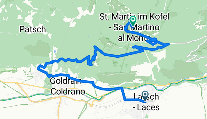
A cycling route starting in Latsch, Trentino-Alto Adige, Italy.
Overview
About this route
Dieser Uphill hat’s in sich! Selbst hartgesottene Uphiller beißen sich an den steilen, losen Schotterrampen die Zähne aus. Dieser extrem fordernde Uphill verläuft von Latsch aus Richtung Westen über Tiss vorbei an den typisch Vinschgerschen Apfelgärten und der Kirche St. Luzius hinauf bis nach Vetzan. Hier beginnt der Forstweg in angenehmer Steigung zum Schloss Annenberg (1040 m, km 8,3; Ziel der GPSBike-CUP-Etappe). Ab diesem tollen Aussichtspunkt in Richtung Martelltal fängt der anspruchsvolle, Kräfte raubende Teil der Tour auf teils grobem, losem Schotter sowie teils sehr steilen Rampen Richtung St. Martin im Kofel an. Nach ca. 10,7 km ist die härteste Passage überwunden und es geht wieder flacher auf Schotterweg und der Asphaltstraße zu unserem Ziel nach St. Martin im Kofel. Gut zu wissen Großteils im Wald; Zwischeneinstiege in Tschilli- und Montesole-Trail. Bis zu 24% Steigung - Schiebestücke mit losem Schotter! Etappe des GPS-Bike CUP Latsch bis Schloss Annenberg Abfahrts- bzw. Anschlussvarianten: Asphaltstraße St. Martin, Annenberg-Easy-Trail (S1), Tschilli-Trail (S2), Montesole-Trail (S2), Panorama-Trail (S3). Traileinstiege: ca. 1 bzw. 1,7 km nach Schloss Annenberg in den Tschilli-Trail (S2) bzw. den Montesole-Trail (S2).
- -:--
- Duration
- 13.8 km
- Distance
- 1,125 m
- Ascent
- 34 m
- Descent
- ---
- Avg. speed
- ---
- Max. altitude

Continue with Bikemap
Use, edit, or download this cycling route
You would like to ride Uphill Schloss-Annenberg or customize it for your own trip? Here is what you can do with this Bikemap route:
Free features
- Save this route as favorite or in collections
- Copy & plan your own version of this route
- Sync your route with Garmin or Wahoo
Premium features
Free trial for 3 days, or one-time payment. More about Bikemap Premium.
- Navigate this route on iOS & Android
- Export a GPX / KML file of this route
- Create your custom printout (try it for free)
- Download this route for offline navigation
Discover more Premium features.
Get Bikemap PremiumFrom our community
Other popular routes starting in Latsch
 Tour zur Marzoner Alm
- Distance
- 30.5 km
- Ascent
- 1,142 m
- Descent
- 1,166 m
- Location
- Latsch, Trentino-Alto Adige, Italy
 Martelltal bis zum Stausee
- Distance
- 48.9 km
- Ascent
- 1,551 m
- Descent
- 1,542 m
- Location
- Latsch, Trentino-Alto Adige, Italy
 Goldrain - Ruine Schloss Montani - Trimdichpfad Latsch - Radweg / St. Martin Seilbahn ;)
- Distance
- 11.9 km
- Ascent
- 1,885 m
- Descent
- 1,953 m
- Location
- Latsch, Trentino-Alto Adige, Italy
 Latscher Trail Zauber S2 (klein)
- Distance
- 11.1 km
- Ascent
- 388 m
- Descent
- 394 m
- Location
- Latsch, Trentino-Alto Adige, Italy
 Vinschgau 05 (Haslhof)
- Distance
- 28.6 km
- Ascent
- 1,284 m
- Descent
- 1,284 m
- Location
- Latsch, Trentino-Alto Adige, Italy
 Uphill Schloss-Annenberg
- Distance
- 13.8 km
- Ascent
- 1,125 m
- Descent
- 34 m
- Location
- Latsch, Trentino-Alto Adige, Italy
 über die Bärenböden
- Distance
- 28.5 km
- Ascent
- 1,098 m
- Descent
- 1,098 m
- Location
- Latsch, Trentino-Alto Adige, Italy
 Latscher Trail Zauber S2 (gross)
- Distance
- 15.8 km
- Ascent
- 552 m
- Descent
- 553 m
- Location
- Latsch, Trentino-Alto Adige, Italy
Open it in the app