

Melk - České Budějovice - Wien (2014)
Želnava - České Budějovice
A cycling route starting in Horní Planá, Jihočeský kraj, Czechia.
Overview
About this route
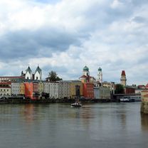
Melk - Passau - Ebreichsdorf, Day 6/9
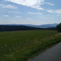
Lipno Reservoir, Český Krumlov, Budweis
unfortunately the camera was broken :(
- -:--
- Duration
- 67.2 km
- Distance
- 312 m
- Ascent
- 705 m
- Descent
- ---
- Avg. speed
- ---
- Max. altitude

Part of
Route quality
Waytypes & surfaces along the route
Waytypes
Quiet road
15.5 km
(23 %)
Road
13.4 km
(20 %)
Surfaces
Paved
43.7 km
(65 %)
Asphalt
42.4 km
(63 %)
Paved (undefined)
1.3 km
(2 %)
Undefined
23.5 km
(35 %)
Continue with Bikemap
Use, edit, or download this cycling route
You would like to ride Želnava - České Budějovice or customize it for your own trip? Here is what you can do with this Bikemap route:
Free features
- Save this route as favorite or in collections
- Copy & plan your own version of this route
- Sync your route with Garmin or Wahoo
Premium features
Free trial for 3 days, or one-time payment. More about Bikemap Premium.
- Navigate this route on iOS & Android
- Export a GPX / KML file of this route
- Create your custom printout (try it for free)
- Download this route for offline navigation
Discover more Premium features.
Get Bikemap PremiumFrom our community
Other popular routes starting in Horní Planá
 Lipno 06
- Distance
- 50.1 km
- Ascent
- 592 m
- Descent
- 597 m
- Location
- Horní Planá, Jihočeský kraj, Czechia
 26.7.2018
- Distance
- 47.6 km
- Ascent
- 349 m
- Descent
- 352 m
- Location
- Horní Planá, Jihočeský kraj, Czechia
 Okolo Lipna
- Distance
- 94.3 km
- Ascent
- 3,801 m
- Descent
- 3,821 m
- Location
- Horní Planá, Jihočeský kraj, Czechia
 Lipno Juh
- Distance
- 57.5 km
- Ascent
- 509 m
- Descent
- 505 m
- Location
- Horní Planá, Jihočeský kraj, Czechia
 Výlet do Rakúska
- Distance
- 45.5 km
- Ascent
- 802 m
- Descent
- 802 m
- Location
- Horní Planá, Jihočeský kraj, Czechia
 Okolo Lipna
- Distance
- 76.3 km
- Ascent
- 471 m
- Descent
- 471 m
- Location
- Horní Planá, Jihočeský kraj, Czechia
 kolem Schwarzenberského kanálu
- Distance
- 49.1 km
- Ascent
- 315 m
- Descent
- 315 m
- Location
- Horní Planá, Jihočeský kraj, Czechia
 Horní Planá, okruh
- Distance
- 28 km
- Ascent
- 265 m
- Descent
- 258 m
- Location
- Horní Planá, Jihočeský kraj, Czechia
Open it in the app