

Latsch Propain Trail Runde S2-S3
A cycling route starting in Latsch, Trentino-Alto Adige, Italy.
Overview
About this route
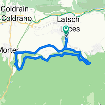
From Latsch towards Goldrain and then on to Vetzan. Then up to the Propain Trail. Now we face the first challenging trail descent with some tricky sections that really test your skills. Upon reaching the water basin, a great cross trail begins, leading us up to just before the asphalt road we biked up earlier. Just before the asphalt, we sharply turn right onto path No. 13 towards Schlanders. Beware, just before Schlanders there are some tricky trail sections that are quite demanding! The tour then takes us to Nördersberg. Return to Latsch via the AigenTrail - BierkellerTrail.
- -:--
- Duration
- 33 km
- Distance
- 1,291 m
- Ascent
- 1,289 m
- Descent
- ---
- Avg. speed
- ---
- Max. altitude

Continue with Bikemap
Use, edit, or download this cycling route
You would like to ride Latsch Propain Trail Runde S2-S3 or customize it for your own trip? Here is what you can do with this Bikemap route:
Free features
- Save this route as favorite or in collections
- Copy & plan your own version of this route
- Sync your route with Garmin or Wahoo
Premium features
Free trial for 3 days, or one-time payment. More about Bikemap Premium.
- Navigate this route on iOS & Android
- Export a GPX / KML file of this route
- Create your custom printout (try it for free)
- Download this route for offline navigation
Discover more Premium features.
Get Bikemap PremiumFrom our community
Other popular routes starting in Latsch
 Latscher Trail Zauber S2 (gross)
- Distance
- 15.8 km
- Ascent
- 552 m
- Descent
- 553 m
- Location
- Latsch, Trentino-Alto Adige, Italy
 über die Bärenböden
- Distance
- 28.5 km
- Ascent
- 1,098 m
- Descent
- 1,098 m
- Location
- Latsch, Trentino-Alto Adige, Italy
 Latsch Trail 13 Runde S2
- Distance
- 16.9 km
- Ascent
- 734 m
- Descent
- 730 m
- Location
- Latsch, Trentino-Alto Adige, Italy
 LatscherAlm-TarscherAlm-MarzonerAlm Tour S2
- Distance
- 48.7 km
- Ascent
- 2,023 m
- Descent
- 2,024 m
- Location
- Latsch, Trentino-Alto Adige, Italy
 Vinschgau 05 (Haslhof)
- Distance
- 28.6 km
- Ascent
- 1,284 m
- Descent
- 1,284 m
- Location
- Latsch, Trentino-Alto Adige, Italy
 Uphill Schloss-Annenberg
- Distance
- 13.8 km
- Ascent
- 1,125 m
- Descent
- 34 m
- Location
- Latsch, Trentino-Alto Adige, Italy
 Tour zur Marzoner Alm
- Distance
- 30.5 km
- Ascent
- 1,142 m
- Descent
- 1,166 m
- Location
- Latsch, Trentino-Alto Adige, Italy
 Latscher Trail Zauber S2 (klein)
- Distance
- 11.1 km
- Ascent
- 388 m
- Descent
- 394 m
- Location
- Latsch, Trentino-Alto Adige, Italy
Open it in the app