

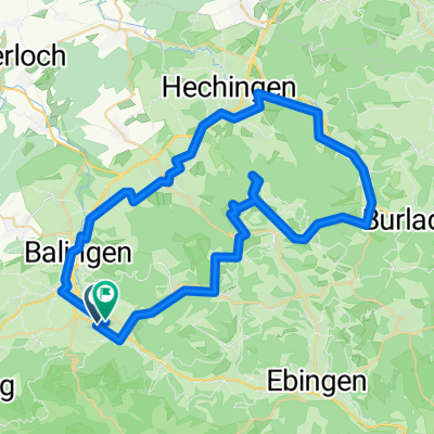
Alb Rand Tour
A cycling route starting in Balingen, Baden-Wurttemberg, Germany.
Overview
About this route
Nur was geübte und schwindelfreie Fahrer. Sonst tolle Tour.
- -:--
- Duration
- 43.2 km
- Distance
- 632 m
- Ascent
- 632 m
- Descent
- ---
- Avg. speed
- ---
- Max. altitude
Continue with Bikemap
Use, edit, or download this cycling route
You would like to ride Alb Rand Tour or customize it for your own trip? Here is what you can do with this Bikemap route:
Free features
- Save this route as favorite or in collections
- Copy & plan your own version of this route
- Sync your route with Garmin or Wahoo
Premium features
Free trial for 3 days, or one-time payment. More about Bikemap Premium.
- Navigate this route on iOS & Android
- Export a GPX / KML file of this route
- Create your custom printout (try it for free)
- Download this route for offline navigation
Discover more Premium features.
Get Bikemap PremiumFrom our community
Other popular routes starting in Balingen
 Hechinger Straße 1, Balingen nach Hechinger Straße 1, Balingen
- Distance
- 20.8 km
- Ascent
- 313 m
- Descent
- 313 m
- Location
- Balingen, Baden-Wurttemberg, Germany
 Zellerhorn
- Distance
- 63.5 km
- Ascent
- 1,137 m
- Descent
- 1,142 m
- Location
- Balingen, Baden-Wurttemberg, Germany
 Relaxed route in Balingen
- Distance
- 68.5 km
- Ascent
- 1,181 m
- Descent
- 1,181 m
- Location
- Balingen, Baden-Wurttemberg, Germany
 4-Seen-Tour
- Distance
- 36.5 km
- Ascent
- 477 m
- Descent
- 368 m
- Location
- Balingen, Baden-Wurttemberg, Germany
 Kloster kirchberg
- Distance
- 50.3 km
- Ascent
- 700 m
- Descent
- 699 m
- Location
- Balingen, Baden-Wurttemberg, Germany
 Traufgang Felsenmeersteig
- Distance
- 16.8 km
- Ascent
- 577 m
- Descent
- 576 m
- Location
- Balingen, Baden-Wurttemberg, Germany
 Lochen Runde
- Distance
- 29.7 km
- Ascent
- 569 m
- Descent
- 560 m
- Location
- Balingen, Baden-Wurttemberg, Germany
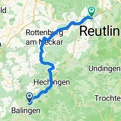 Balingen - Tübingen
- Distance
- 51.3 km
- Ascent
- 442 m
- Descent
- 644 m
- Location
- Balingen, Baden-Wurttemberg, Germany
Open it in the app