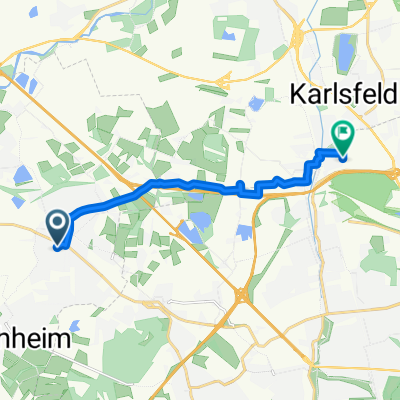
Rennradrunde 76km
A cycling route starting in Gröbenzell, Bavaria, Germany.
Overview
About this route
Schnelle Runde In Richtung FFB, Schöngeising, Mauern, Grafrath, Türkenfeld, Jesenwang, Schöngeising, Biburg, Alling und Puchheim. Meine Fahrzeit : 2:38, Schnitt 29 Kmh.
- -:--
- Duration
- 67.2 km
- Distance
- 290 m
- Ascent
- 290 m
- Descent
- ---
- Avg. speed
- ---
- Avg. speed
Route quality
Waytypes & surfaces along the route
Waytypes
Quiet road
29.3 km
(44 %)
Road
21.3 km
(32 %)
Surfaces
Paved
66.8 km
(99 %)
Unpaved
0.1 km
(<1 %)
Asphalt
65.6 km
(98 %)
Concrete
1 km
(2 %)
Continue with Bikemap
Use, edit, or download this cycling route
You would like to ride Rennradrunde 76km or customize it for your own trip? Here is what you can do with this Bikemap route:
Free features
- Save this route as favorite or in collections
- Copy & plan your own version of this route
- Sync your route with Garmin or Wahoo
Premium features
Free trial for 3 days, or one-time payment. More about Bikemap Premium.
- Navigate this route on iOS & Android
- Export a GPX / KML file of this route
- Create your custom printout (try it for free)
- Download this route for offline navigation
Discover more Premium features.
Get Bikemap PremiumFrom our community
Other popular routes starting in Gröbenzell
- Amperrunde über alte Bahnlinie
- Distance
- 24.1 km
- Ascent
- 48 m
- Descent
- 45 m
- Location
- Gröbenzell, Bavaria, Germany
- Von Gröbenzell bis München
- Distance
- 20.5 km
- Ascent
- 63 m
- Descent
- 55 m
- Location
- Gröbenzell, Bavaria, Germany
- Rennradrunde 76km
- Distance
- 67.2 km
- Ascent
- 290 m
- Descent
- 290 m
- Location
- Gröbenzell, Bavaria, Germany
- Räuber Kneißl Radweg 1
- Distance
- 30.4 km
- Ascent
- 54 m
- Descent
- 54 m
- Location
- Gröbenzell, Bavaria, Germany
- Puchheim - Jexhof
- Distance
- 44.3 km
- Ascent
- 204 m
- Descent
- 205 m
- Location
- Gröbenzell, Bavaria, Germany
- Trainingsrunde ca. 40km
- Distance
- 39 km
- Ascent
- 140 m
- Descent
- 143 m
- Location
- Gröbenzell, Bavaria, Germany
- Frühlingstour
- Distance
- 59.1 km
- Ascent
- 172 m
- Descent
- 172 m
- Location
- Gröbenzell, Bavaria, Germany
- Vom Böhmerweiher nach Aubing (München)
- Distance
- 4.8 km
- Ascent
- 58 m
- Descent
- 56 m
- Location
- Gröbenzell, Bavaria, Germany
Open it in the app