

2020 Ruta Nº 31
A cycling route starting in Valladolid, Castille and León, Spain.
Overview
About this route
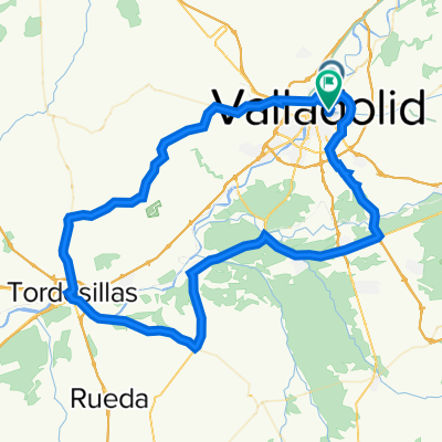
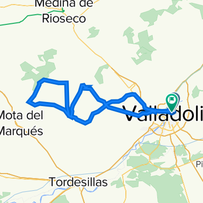
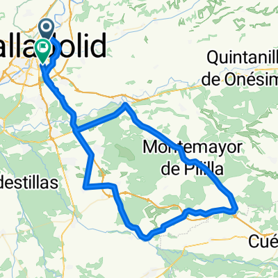
Renedo – Villabáñez – Olivares – Castrillo Villavaquerin-Villabáñez-(Tudela-exterior) – Ctra.Maricas -Pte.Herrera-La Corala-Cisterniga (Cerro San Cristóbal)- Valladolid
1st Climb: Canteras (1)
Average gradient 8.40%
Distance 2.2 Km.
2nd Climb: Páramo Rozas del Duero (1) -
Average gradient 3.40% -
Distance 3.6 Km.
3rd Climb Atalayas
Average gradient 4.7%
Distance 2.9 Km.
4th Climb: Cerro San Cristobal
Average gradient 7.6 %
Distance 1.2 Km.
- -:--
- Duration
- 88.9 km
- Distance
- 637 m
- Ascent
- 639 m
- Descent
- ---
- Avg. speed
- ---
- Max. altitude

Route quality
Waytypes & surfaces along the route
Waytypes
Road
63.2 km
(71 %)
Quiet road
7.1 km
(8 %)
Surfaces
Paved
75.6 km
(85 %)
Unpaved
7.1 km
(8 %)
Asphalt
74.7 km
(84 %)
Gravel
7.1 km
(8 %)
Route highlights
Points of interest along the route
Point of interest after 10.1 km
1ª Subida: Canteras (1) Pendiente media 8,40% Distancia 2,2 Km.
Point of interest after 20.2 km
2ª Subida: Páramo Rozas del Duero (1) - Pendiente media 3,40% - Distancia 3,6 Km.
Point of interest after 34.1 km
Subida Atalayas Pendiente media 4,7% Distancia 2,9 Km.
Point of interest after 82.4 km
4º Subida: Cerro San Cristobal Pendiente media 7,6 % Distancia 1,2 Km.
Continue with Bikemap
Use, edit, or download this cycling route
You would like to ride 2020 Ruta Nº 31 or customize it for your own trip? Here is what you can do with this Bikemap route:
Free features
- Save this route as favorite or in collections
- Copy & plan your own version of this route
- Split it into stages to create a multi-day tour
- Sync your route with Garmin or Wahoo
Premium features
Free trial for 3 days, or one-time payment. More about Bikemap Premium.
- Navigate this route on iOS & Android
- Export a GPX / KML file of this route
- Create your custom printout (try it for free)
- Download this route for offline navigation
Discover more Premium features.
Get Bikemap PremiumFrom our community
Other popular routes starting in Valladolid
 2022 - Ruta nº 096
- Distance
- 97.2 km
- Ascent
- 2,072 m
- Descent
- 2,072 m
- Location
- Valladolid, Castille and León, Spain
 Circuito: (Parameño Valladolid)
- Distance
- 37.2 km
- Ascent
- 254 m
- Descent
- 257 m
- Location
- Valladolid, Castille and León, Spain
 2022 Ruta Nº 077
- Distance
- 103.3 km
- Ascent
- 719 m
- Descent
- 719 m
- Location
- Valladolid, Castille and León, Spain
 2022 Ruta Nº 083
- Distance
- 83.7 km
- Ascent
- 358 m
- Descent
- 359 m
- Location
- Valladolid, Castille and León, Spain
 Ruta: 20-Mayo-2018 - (PM - Amistad)
- Distance
- 92.8 km
- Ascent
- 435 m
- Descent
- 431 m
- Location
- Valladolid, Castille and León, Spain
 2020 Ruta Nº 31
- Distance
- 88.9 km
- Ascent
- 637 m
- Descent
- 639 m
- Location
- Valladolid, Castille and León, Spain
 2022 Ruta Nº 065
- Distance
- 99.9 km
- Ascent
- 711 m
- Descent
- 715 m
- Location
- Valladolid, Castille and León, Spain
 Circuito: VAREVITUCI
- Distance
- 37.6 km
- Ascent
- 303 m
- Descent
- 303 m
- Location
- Valladolid, Castille and León, Spain
Open it in the app