

Mank-Hofstetten-Mank
A cycling route starting in Mank, Lower Austria, Austria.
Overview
About this route
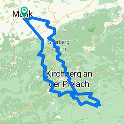
From the starting point at the municipal office in Mank, you head east around the city, over rural paths to Poppendorf, Großaigen. After crossing the main road, you climb through Fleischessen to Panschach and continue to Freyen. Now the incline gets quite steep with technical sections through the forest. After crossing the Kohlenberg, you go through forest paths and trails to Mainburg. Relaxing on the bike path towards Hofstetten, and then steeply up to Plambach. Attention, a short section after the farmhouse is private across a meadow.
After a short elevated path, a relaxing descent to Hofstetten. Through the village, passing the Grünauer Church, and steadily uphill to the Römerweg (651).
On wonderful paths through the woods, passing by Hamas back to Kohlenbergstraße. Here, turn right for 400 m, then sharply right downhill for a short technical section. Back on the road and down to Kilb. Through the village over Wötzling, the bike-friendly railway track, and Guglberg to Großaigen.
Here, a stop is planned at the cyclist-friendly ZETTELBACHSTÜBERL. After that, 2 km on the road back to the starting point.
HOP HOP - LET'S GO!!
- -:--
- Duration
- 49.2 km
- Distance
- 825 m
- Ascent
- 825 m
- Descent
- ---
- Avg. speed
- ---
- Max. altitude

Route highlights
Points of interest along the route
Point of interest after 2.4 km
Gasthaus ZETTELBACHSTÜBERL
Continue with Bikemap
Use, edit, or download this cycling route
You would like to ride Mank-Hofstetten-Mank or customize it for your own trip? Here is what you can do with this Bikemap route:
Free features
- Save this route as favorite or in collections
- Copy & plan your own version of this route
- Sync your route with Garmin or Wahoo
Premium features
Free trial for 3 days, or one-time payment. More about Bikemap Premium.
- Navigate this route on iOS & Android
- Export a GPX / KML file of this route
- Create your custom printout (try it for free)
- Download this route for offline navigation
Discover more Premium features.
Get Bikemap PremiumFrom our community
Other popular routes starting in Mank
 Mank - Texingtal - Mank
- Distance
- 25.2 km
- Ascent
- 380 m
- Descent
- 380 m
- Location
- Mank, Lower Austria, Austria
 Hiesberg, Ruine Zelking - Variante I
- Distance
- 39.4 km
- Ascent
- 686 m
- Descent
- 685 m
- Location
- Mank, Lower Austria, Austria
 Schöngrabenrunde
- Distance
- 54.8 km
- Ascent
- 1,825 m
- Descent
- 1,826 m
- Location
- Mank, Lower Austria, Austria
 AustriaTour_czI - Mank-Villach
- Distance
- 569 km
- Ascent
- 3,252 m
- Descent
- 3,052 m
- Location
- Mank, Lower Austria, Austria
 Luft-Fischbach-Runde
- Distance
- 28 km
- Ascent
- 815 m
- Descent
- 814 m
- Location
- Mank, Lower Austria, Austria
 Luft und Texinger Berg
- Distance
- 32.7 km
- Ascent
- 851 m
- Descent
- 851 m
- Location
- Mank, Lower Austria, Austria
 Mank-Hofstetten-Mank
- Distance
- 49.2 km
- Ascent
- 825 m
- Descent
- 825 m
- Location
- Mank, Lower Austria, Austria
 Oberndorfer Höhe-Texinger Berg
- Distance
- 42.2 km
- Ascent
- 690 m
- Descent
- 690 m
- Location
- Mank, Lower Austria, Austria
Open it in the app