

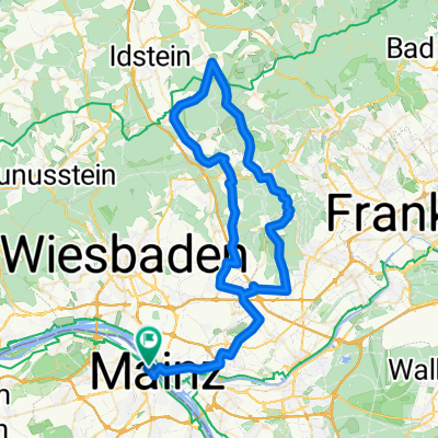
Windräder-Tour - RTF des Mainzer Radsportverein 1889 e.V. - 115 km Strecke
A cycling route starting in Mainz, Rhineland-Palatinate, Germany.
Overview
About this route
Windräder-Tour - 115 km
RTF des Mainzer Radsportverein 1889 e.V.
Alle weiteren Hinweise zu dieser Strecke -> hier anklicken
- -:--
- Duration
- 114.8 km
- Distance
- 572 m
- Ascent
- 572 m
- Descent
- ---
- Avg. speed
- ---
- Max. altitude

Route photos

Route quality
Waytypes & surfaces along the route
Waytypes
Busy road
34.3 km
(30 %)
Road
32.8 km
(29 %)
Surfaces
Paved
102.5 km
(89 %)
Unpaved
4.4 km
(4 %)
Asphalt
94.8 km
(83 %)
Paved (undefined)
4 km
(3 %)
Continue with Bikemap
Use, edit, or download this cycling route
You would like to ride Windräder-Tour - RTF des Mainzer Radsportverein 1889 e.V. - 115 km Strecke or customize it for your own trip? Here is what you can do with this Bikemap route:
Free features
- Save this route as favorite or in collections
- Copy & plan your own version of this route
- Split it into stages to create a multi-day tour
- Sync your route with Garmin or Wahoo
Premium features
Free trial for 3 days, or one-time payment. More about Bikemap Premium.
- Navigate this route on iOS & Android
- Export a GPX / KML file of this route
- Create your custom printout (try it for free)
- Download this route for offline navigation
Discover more Premium features.
Get Bikemap PremiumFrom our community
Other popular routes starting in Mainz
 Feldberg-Runde (direkt & bergig)
- Distance
- 92.7 km
- Ascent
- 1,300 m
- Descent
- 1,302 m
- Location
- Mainz, Rhineland-Palatinate, Germany
 20190831 Rheinrunde
- Distance
- 52.5 km
- Ascent
- 82 m
- Descent
- 85 m
- Location
- Mainz, Rhineland-Palatinate, Germany
 Mainz-Lorsbachtal-Heftrich-Niedernhausen-Mainz
- Distance
- 82.4 km
- Ascent
- 719 m
- Descent
- 720 m
- Location
- Mainz, Rhineland-Palatinate, Germany
 Rheinhessentour um Mainz
- Distance
- 30.6 km
- Ascent
- 278 m
- Descent
- 278 m
- Location
- Mainz, Rhineland-Palatinate, Germany
 Tiger and Muesli
- Distance
- 59.2 km
- Ascent
- 621 m
- Descent
- 565 m
- Location
- Mainz, Rhineland-Palatinate, Germany
 De: Mainz Süd süss
- Distance
- 54.9 km
- Ascent
- 568 m
- Descent
- 555 m
- Location
- Mainz, Rhineland-Palatinate, Germany
 In alte Gefilde
- Distance
- 50 km
- Ascent
- 365 m
- Descent
- 362 m
- Location
- Mainz, Rhineland-Palatinate, Germany
 Mz-Kastel - Feldberg - Mz-Kastel
- Distance
- 94.6 km
- Ascent
- 1,496 m
- Descent
- 1,432 m
- Location
- Mainz, Rhineland-Palatinate, Germany
Open it in the app