
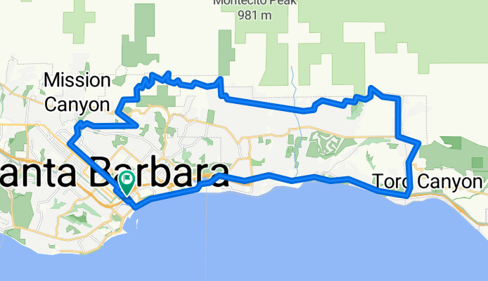
Santa Barbara Mountain Drive Ride
A cycling route starting in Santa Barbara, California, United States.
Overview
About this route
Start and end at The Wayfarer, SB.
- -:--
- Duration
- 41 km
- Distance
- 585 m
- Ascent
- 585 m
- Descent
- ---
- Avg. speed
- ---
- Max. altitude

Route quality
Waytypes & surfaces along the route
Waytypes
Quiet road
22.6 km
(55 %)
Road
7 km
(17 %)
Surfaces
Paved
18 km
(44 %)
Asphalt
17.2 km
(42 %)
Concrete
0.8 km
(2 %)
Undefined
23 km
(56 %)
Continue with Bikemap
Use, edit, or download this cycling route
You would like to ride Santa Barbara Mountain Drive Ride or customize it for your own trip? Here is what you can do with this Bikemap route:
Free features
- Save this route as favorite or in collections
- Copy & plan your own version of this route
- Sync your route with Garmin or Wahoo
Premium features
Free trial for 3 days, or one-time payment. More about Bikemap Premium.
- Navigate this route on iOS & Android
- Export a GPX / KML file of this route
- Create your custom printout (try it for free)
- Download this route for offline navigation
Discover more Premium features.
Get Bikemap PremiumFrom our community
Other popular routes starting in Santa Barbara
 Coronel Place 525, Santa Barbara to Coronel Place 524, Santa Barbara
- Distance
- 45.7 km
- Ascent
- 1,898 m
- Descent
- 1,642 m
- Location
- Santa Barbara, California, United States
 Mission Ridge Los Canoas
- Distance
- 17.3 km
- Ascent
- 295 m
- Descent
- 298 m
- Location
- Santa Barbara, California, United States
 Gibraltar Santa Barbara 60km loop
- Distance
- 60.1 km
- Ascent
- 1,425 m
- Descent
- 1,421 m
- Location
- Santa Barbara, California, United States
 Bikes to go trip
- Distance
- 15.8 km
- Ascent
- 90 m
- Descent
- 88 m
- Location
- Santa Barbara, California, United States
 Aufnahme vom 11.05.2016, 18:14
- Distance
- 22.8 km
- Ascent
- 390 m
- Descent
- 385 m
- Location
- Santa Barbara, California, United States
 Santa Barbara Mountain Drive Ride
- Distance
- 41 km
- Ascent
- 585 m
- Descent
- 585 m
- Location
- Santa Barbara, California, United States
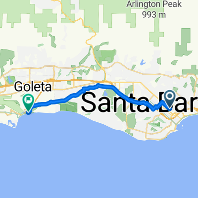 From Santa Barbara to Goleta
- Distance
- 15.1 km
- Ascent
- 116 m
- Descent
- 128 m
- Location
- Santa Barbara, California, United States
 Helena Ave, Santa Barbara to E Mason St, Santa Barbara
- Distance
- 7.3 km
- Ascent
- 58 m
- Descent
- 58 m
- Location
- Santa Barbara, California, United States
Open it in the app