

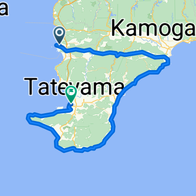
Minami Boso Loop
A cycling route starting in Tateyama, Chiba, Japan.
Overview
About this route
Loop from Nanbo Kokusai Mura up over the mountain and then around the coast.
- -:--
- Duration
- 58.9 km
- Distance
- 176 m
- Ascent
- 176 m
- Descent
- ---
- Avg. speed
- ---
- Max. altitude

Route quality
Waytypes & surfaces along the route
Waytypes
Road
11.8 km
(20 %)
Cycleway
11.2 km
(19 %)
Surfaces
Paved
20.6 km
(35 %)
Asphalt
20 km
(34 %)
Paved (undefined)
0.6 km
(1 %)
Undefined
38.3 km
(65 %)
Route highlights
Points of interest along the route

Point of interest after 6.1 km
Checkpoint #1 Border between Tateyama and Minami Boso

Point of interest after 13.9 km
Checkpoint #2 T-junction at Yawata Beach traffic light

Point of interest after 22.1 km
Checkpoint #3 Kokumin Kyukamura Tateyama (Q kamura)

Point of interest after 33.3 km
Checkpoint #4 Lucky’s Trailer Village/cafe

Point of interest after 43.7 km
Checkpoint #5 Shirahama/Nojimazaki lighthouse

Point of interest after 50.2 km
Checkpoint #6 Shiramazu on the bridge in front of mermaid
Continue with Bikemap
Use, edit, or download this cycling route
You would like to ride Minami Boso Loop or customize it for your own trip? Here is what you can do with this Bikemap route:
Free features
- Save this route as favorite or in collections
- Copy & plan your own version of this route
- Sync your route with Garmin or Wahoo
Premium features
Free trial for 3 days, or one-time payment. More about Bikemap Premium.
- Navigate this route on iOS & Android
- Export a GPX / KML file of this route
- Create your custom printout (try it for free)
- Download this route for offline navigation
Discover more Premium features.
Get Bikemap PremiumFrom our community
Other popular routes starting in Tateyama
 南房総“菜の花サイクリング"
- Distance
- 57.8 km
- Ascent
- 347 m
- Descent
- 346 m
- Location
- Tateyama, Chiba, Japan
 20210919 南房総
- Distance
- 61.8 km
- Ascent
- 264 m
- Descent
- 261 m
- Location
- Tateyama, Chiba, Japan
 CCA里山・里海サイクリング 2020
- Distance
- 65 km
- Ascent
- 801 m
- Descent
- 806 m
- Location
- Tateyama, Chiba, Japan
 Boso S3: Chikura - Hatake - Shirahama
- Distance
- 11.2 km
- Ascent
- 247 m
- Descent
- 245 m
- Location
- Tateyama, Chiba, Japan
 Awakatsuyama-Awakamogawa-Chikura-Tateyama
- Distance
- 95.2 km
- Ascent
- 299 m
- Descent
- 298 m
- Location
- Tateyama, Chiba, Japan
 Yawata, Tateyama à Hama, Onjuku
- Distance
- 100 km
- Ascent
- 810 m
- Descent
- 809 m
- Location
- Tateyama, Chiba, Japan
 Minami Boso Loop
- Distance
- 58.9 km
- Ascent
- 176 m
- Descent
- 176 m
- Location
- Tateyama, Chiba, Japan
 Chikura-Tateyama-Chikura
- Distance
- 56.3 km
- Ascent
- 223 m
- Descent
- 221 m
- Location
- Tateyama, Chiba, Japan
Open it in the app