

Luft und Texinger Berg
A cycling route starting in Mank, Lower Austria, Austria.
Overview
About this route
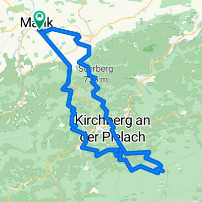
Start and end are in Mank, Schulstraße. Free parking available.
Route goes from Mank through Groß Aigen, Kuhberg, Luft, Höllgraben, Texing, Texinger Berg, Sattlehen, Kirnberg back to Mank.
- -:--
- Duration
- 32.7 km
- Distance
- 851 m
- Ascent
- 851 m
- Descent
- ---
- Avg. speed
- ---
- Max. altitude

Route highlights
Points of interest along the route
Point of interest after 13.2 km
Sandler Kapelle
Point of interest after 19.4 km
Einkehrmöglichkeit im netten Ortswirtshaus Schrittwieser
Point of interest after 26.6 km
Einkehrmöglichkeit im netten Ortswirtshaus Griessler
Continue with Bikemap
Use, edit, or download this cycling route
You would like to ride Luft und Texinger Berg or customize it for your own trip? Here is what you can do with this Bikemap route:
Free features
- Save this route as favorite or in collections
- Copy & plan your own version of this route
- Sync your route with Garmin or Wahoo
Premium features
Free trial for 3 days, or one-time payment. More about Bikemap Premium.
- Navigate this route on iOS & Android
- Export a GPX / KML file of this route
- Create your custom printout (try it for free)
- Download this route for offline navigation
Discover more Premium features.
Get Bikemap PremiumFrom our community
Other popular routes starting in Mank
 Hochsteinberg-GeheimtippRunde
- Distance
- 26.2 km
- Ascent
- 613 m
- Descent
- 610 m
- Location
- Mank, Lower Austria, Austria
 AustriaTour_czI - Mank-Villach
- Distance
- 569 km
- Ascent
- 3,252 m
- Descent
- 3,052 m
- Location
- Mank, Lower Austria, Austria
 Flache Runde
- Distance
- 73.9 km
- Ascent
- 1,072 m
- Descent
- 1,080 m
- Location
- Mank, Lower Austria, Austria
 Zeitmeßstrecke f. Luki
- Distance
- 23 km
- Ascent
- 224 m
- Descent
- 229 m
- Location
- Mank, Lower Austria, Austria
 Hiesberg, Ruine Zelking - Variante I
- Distance
- 39.4 km
- Ascent
- 686 m
- Descent
- 685 m
- Location
- Mank, Lower Austria, Austria
 Schöngrabenrunde
- Distance
- 54.8 km
- Ascent
- 1,825 m
- Descent
- 1,826 m
- Location
- Mank, Lower Austria, Austria
 Mank-Hofstetten-Mank
- Distance
- 49.2 km
- Ascent
- 825 m
- Descent
- 825 m
- Location
- Mank, Lower Austria, Austria
 Luft und Texinger Berg
- Distance
- 32.7 km
- Ascent
- 851 m
- Descent
- 851 m
- Location
- Mank, Lower Austria, Austria
Open it in the app