
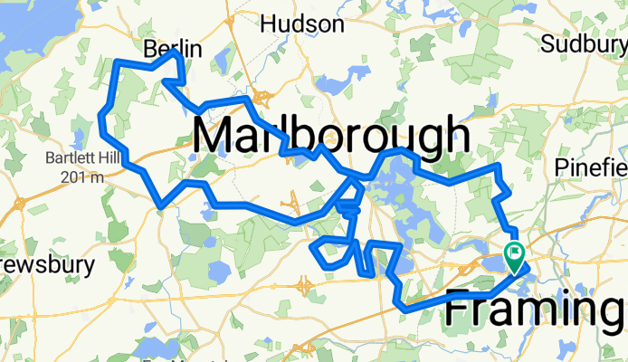
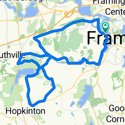
Joe's Northwest Passage
A cycling route starting in Framingham Center, Massachusetts, United States of America.
Overview
About this route
Joe Repole''s CRW ride 3/28/10
- -:--
- Duration
- 75.5 km
- Distance
- 677 m
- Ascent
- 651 m
- Descent
- ---
- Avg. speed
- 197 m
- Max. altitude

Route quality
Waytypes & surfaces along the route
Waytypes
Road
39.2 km
(52 %)
Quiet road
22 km
(29 %)
Surfaces
Paved
35.4 km
(47 %)
Asphalt
35.3 km
(47 %)
Paved (undefined)
0.1 km
(<1 %)
Undefined
40.1 km
(53 %)
Route highlights
Points of interest along the route
Point of interest after 15.4 km
Split 25/50
Point of interest after 31.1 km
I went up this way. :o(
Point of interest after 37.6 km
I think this is where I turned left (there was an arrow)
Continue with Bikemap
Use, edit, or download this cycling route
You would like to ride Joe's Northwest Passage or customize it for your own trip? Here is what you can do with this Bikemap route:
Free features
- Save this route as favorite or in collections
- Copy & plan your own version of this route
- Sync your route with Garmin or Wahoo
Premium features
Free trial for 3 days, or one-time payment. More about Bikemap Premium.
- Navigate this route on iOS & Android
- Export a GPX / KML file of this route
- Create your custom printout (try it for free)
- Download this route for offline navigation
Discover more Premium features.
Get Bikemap PremiumFrom our community
Other popular routes starting in Framingham Center
 Test route
- Distance
- 36.7 km
- Ascent
- 133 m
- Descent
- 135 m
- Location
- Framingham Center, Massachusetts, United States of America
 trial
trial- Distance
- 5.4 km
- Ascent
- 11 m
- Descent
- 24 m
- Location
- Framingham Center, Massachusetts, United States of America
 Joe's Northwest Passage
- Distance
- 75.5 km
- Ascent
- 677 m
- Descent
- 651 m
- Location
- Framingham Center, Massachusetts, United States of America
 Landham Road, Garden in the Woods
- Distance
- 27.5 km
- Ascent
- 133 m
- Descent
- 133 m
- Location
- Framingham Center, Massachusetts, United States of America
 Test route 2
- Distance
- 105.5 km
- Ascent
- 400 m
- Descent
- 398 m
- Location
- Framingham Center, Massachusetts, United States of America
 Central Street 322, Framingham to Central Street 322, Framingham
- Distance
- 8 km
- Ascent
- 39 m
- Descent
- 35 m
- Location
- Framingham Center, Massachusetts, United States of America
 work home
- Distance
- 15.8 km
- Ascent
- 116 m
- Descent
- 100 m
- Location
- Framingham Center, Massachusetts, United States of America
 Hopkinton State Park loop
- Distance
- 29.3 km
- Ascent
- 240 m
- Descent
- 236 m
- Location
- Framingham Center, Massachusetts, United States of America
Open it in the app