

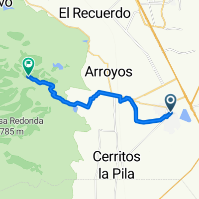
la cantera- cerro de san pedro
A cycling route starting in La Pila, San Luis Potosí, Mexico.
Overview
About this route
- 3 h 19 min
- Duration
- 46.4 km
- Distance
- 267 m
- Ascent
- 268 m
- Descent
- 14 km/h
- Avg. speed
- ---
- Max. altitude

Route photos


Continue with Bikemap
Use, edit, or download this cycling route
You would like to ride la cantera- cerro de san pedro or customize it for your own trip? Here is what you can do with this Bikemap route:
Free features
- Save this route as favorite or in collections
- Copy & plan your own version of this route
- Sync your route with Garmin or Wahoo
Premium features
Free trial for 3 days, or one-time payment. More about Bikemap Premium.
- Navigate this route on iOS & Android
- Export a GPX / KML file of this route
- Create your custom printout (try it for free)
- Download this route for offline navigation
Discover more Premium features.
Get Bikemap PremiumFrom our community
Other popular routes starting in La Pila
 ojo de agua, pozos
- Distance
- 13.1 km
- Ascent
- 28 m
- Descent
- 32 m
- Location
- La Pila, San Luis Potosí, Mexico
 PRIMERA RUTA🥷🏽
- Distance
- 13.3 km
- Ascent
- 422 m
- Descent
- 64 m
- Location
- La Pila, San Luis Potosí, Mexico
 De Francisco I. Madero 365, San Luis Potosí a Calle Jose Ciriaco Cruz 480, San Luis Potosí
- Distance
- 24.3 km
- Ascent
- 69 m
- Descent
- 63 m
- Location
- La Pila, San Luis Potosí, Mexico
 De Calle Jose Ciriaco Cruz 480, San Luis Potosí a Francisco I. Madero 365, San Luis Potosí
- Distance
- 23.8 km
- Ascent
- 54 m
- Descent
- 26 m
- Location
- La Pila, San Luis Potosí, Mexico
 Ruta a Loma del Pedregal 101, San Luis Potosí
- Distance
- 10.9 km
- Ascent
- 135 m
- Descent
- 153 m
- Location
- La Pila, San Luis Potosí, Mexico
 Los Lagos
- Distance
- 5 km
- Ascent
- 37 m
- Descent
- 19 m
- Location
- La Pila, San Luis Potosí, Mexico
 Ruta desde Calle Lago Belch, San Luis Potosí
- Distance
- 7.9 km
- Ascent
- 10 m
- Descent
- 16 m
- Location
- La Pila, San Luis Potosí, Mexico
 Porfirio Díaz 620, San Luis Potosí to Porfirio Díaz 595, San Luis Potosí
- Distance
- 18.3 km
- Ascent
- 46 m
- Descent
- 45 m
- Location
- La Pila, San Luis Potosí, Mexico
Open it in the app