
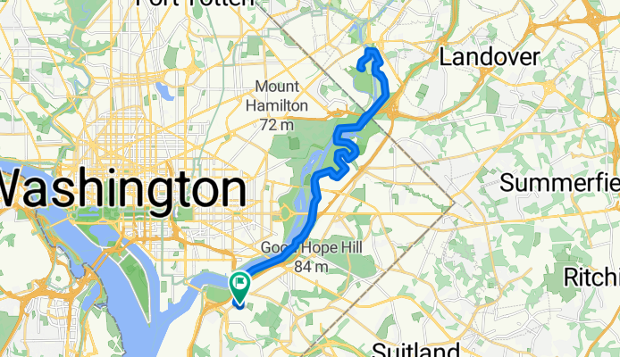
Anacostia River Trail
A cycling route starting in Hillcrest Heights, Maryland, United States.
Overview
About this route
- -:--
- Duration
- 29.4 km
- Distance
- 70 m
- Ascent
- 71 m
- Descent
- ---
- Avg. speed
- ---
- Max. altitude

Route quality
Waytypes & surfaces along the route
Waytypes
Cycleway
22.8 km
(78 %)
Path
3.4 km
(12 %)
Surfaces
Paved
27.2 km
(93 %)
Asphalt
14.4 km
(49 %)
Paved (undefined)
9.1 km
(31 %)
Continue with Bikemap
Use, edit, or download this cycling route
You would like to ride Anacostia River Trail or customize it for your own trip? Here is what you can do with this Bikemap route:
Free features
- Save this route as favorite or in collections
- Copy & plan your own version of this route
- Sync your route with Garmin or Wahoo
Premium features
Free trial for 3 days, or one-time payment. More about Bikemap Premium.
- Navigate this route on iOS & Android
- Export a GPX / KML file of this route
- Create your custom printout (try it for free)
- Download this route for offline navigation
Discover more Premium features.
Get Bikemap PremiumFrom our community
Other popular routes starting in Hillcrest Heights
 1102 Good Hope Rd SE, Washington to DC-295 S, Washington
- Distance
- 4.7 km
- Ascent
- 0 m
- Descent
- 4 m
- Location
- Hillcrest Heights, Maryland, United States
 Stress Free North route
- Distance
- 11 km
- Ascent
- 87 m
- Descent
- 59 m
- Location
- Hillcrest Heights, Maryland, United States
 Commute From Southern
- Distance
- 9.4 km
- Ascent
- 83 m
- Descent
- 49 m
- Location
- Hillcrest Heights, Maryland, United States
 Route to 14950 Potomac Heights Pl, Woodbridge
- Distance
- 48.7 km
- Ascent
- 304 m
- Descent
- 313 m
- Location
- Hillcrest Heights, Maryland, United States
 Anacostia River Trail
- Distance
- 29.4 km
- Ascent
- 70 m
- Descent
- 71 m
- Location
- Hillcrest Heights, Maryland, United States
 Slow ride in Washington
- Distance
- 15.4 km
- Ascent
- 0 m
- Descent
- 7 m
- Location
- Hillcrest Heights, Maryland, United States
 3002 Stanton Rd SE, Washington to 3004 Stanton Rd SE, Washington
- Distance
- 2.1 km
- Ascent
- 34 m
- Descent
- 37 m
- Location
- Hillcrest Heights, Maryland, United States
 ANACOSTIA-GREENBELT-ANACOSTIA
- Distance
- 48.7 km
- Ascent
- 91 m
- Descent
- 91 m
- Location
- Hillcrest Heights, Maryland, United States
Open it in the app