

Ciloturismo pelas Aldeias Históricas Dia2/14
A cycling route starting in Tomar, Santarém District, Portugal.
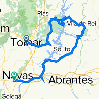
Overview
About this route
- -:--
- Duration
- 63.9 km
- Distance
- 513 m
- Ascent
- 529 m
- Descent
- ---
- Avg. speed
- ---
- Max. altitude

Route quality
Waytypes & surfaces along the route
Waytypes
Quiet road
11.5 km
(18 %)
Road
9.6 km
(15 %)
Surfaces
Paved
47.9 km
(75 %)
Asphalt
47.9 km
(75 %)
Undefined
16 km
(25 %)
Continue with Bikemap
Use, edit, or download this cycling route
You would like to ride Ciloturismo pelas Aldeias Históricas Dia2/14 or customize it for your own trip? Here is what you can do with this Bikemap route:
Free features
- Save this route as favorite or in collections
- Copy & plan your own version of this route
- Sync your route with Garmin or Wahoo
Premium features
Free trial for 3 days, or one-time payment. More about Bikemap Premium.
- Navigate this route on iOS & Android
- Export a GPX / KML file of this route
- Create your custom printout (try it for free)
- Download this route for offline navigation
Discover more Premium features.
Get Bikemap PremiumFrom our community
Other popular routes starting in Tomar
 Tomar Serra Agroal
- Distance
- 52.4 km
- Ascent
- 710 m
- Descent
- 703 m
- Location
- Tomar, Santarém District, Portugal
 Caminho Portugues 3. Etappe
- Distance
- 87.2 km
- Ascent
- 784 m
- Descent
- 762 m
- Location
- Tomar, Santarém District, Portugal
 Singletrack Tomar
- Distance
- 32.4 km
- Ascent
- 491 m
- Descent
- 491 m
- Location
- Tomar, Santarém District, Portugal
 Tomar to Ansiao Day #4 March 23rd
- Distance
- 42.5 km
- Ascent
- 380 m
- Descent
- 240 m
- Location
- Tomar, Santarém District, Portugal
 Tomar-Barreiras-Zezere-Tomar
- Distance
- 40.2 km
- Ascent
- 438 m
- Descent
- 438 m
- Location
- Tomar, Santarém District, Portugal
 Tomar - Ansião - Conimbriga - Coimbra
- Distance
- 96.1 km
- Ascent
- 1,169 m
- Descent
- 1,171 m
- Location
- Tomar, Santarém District, Portugal
 Ciloturismo pelas Aldeias Históricas Dia2/14
- Distance
- 63.9 km
- Ascent
- 513 m
- Descent
- 529 m
- Location
- Tomar, Santarém District, Portugal
 Tomar - Vila de Rei - Constância - Entroncamento
- Distance
- 103.9 km
- Ascent
- 1,030 m
- Descent
- 1,048 m
- Location
- Tomar, Santarém District, Portugal
Open it in the app