

Overview
About this route
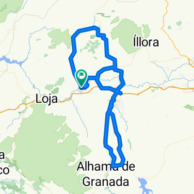
HUETOR TAJAR - ILLORA - PINOS PUENT - CAPARACENA - CUBILLAS (AV) - RUTA LAS FORTALEZAS - ATARFE - SIERRA ELVIRA - PINOS PUENTE - ZUJAIRA - ILLORA - TOCÓN (REAGRUPAMIENTO) - HUETOR TAJAR
- -:--
- Duration
- 95.3 km
- Distance
- 633 m
- Ascent
- 637 m
- Descent
- ---
- Avg. speed
- ---
- Max. altitude

Part of
ABRIL 2018
1 stage
Route quality
Waytypes & surfaces along the route
Waytypes
Road
31.4 km
(33 %)
Quiet road
18.1 km
(19 %)
Surfaces
Paved
63.9 km
(67 %)
Unpaved
1.9 km
(2 %)
Asphalt
63.9 km
(67 %)
Unpaved (undefined)
1.9 km
(2 %)
Undefined
29.5 km
(31 %)
Continue with Bikemap
Use, edit, or download this cycling route
You would like to ride SALIDA 29 DE ABRIL 2018 or customize it for your own trip? Here is what you can do with this Bikemap route:
Free features
- Save this route as favorite or in collections
- Copy & plan your own version of this route
- Split it into stages to create a multi-day tour
- Sync your route with Garmin or Wahoo
Premium features
Free trial for 3 days, or one-time payment. More about Bikemap Premium.
- Navigate this route on iOS & Android
- Export a GPX / KML file of this route
- Create your custom printout (try it for free)
- Download this route for offline navigation
Discover more Premium features.
Get Bikemap PremiumFrom our community
Other popular routes starting in Huétor-Tájar
 SALIDA 4 FEBRERO 2018
- Distance
- 87.8 km
- Ascent
- 495 m
- Descent
- 495 m
- Location
- Huétor-Tájar, Andalusia, Spain
 SALIDA EN FASE 2 DESESCALADA - Ruta Corta
- Distance
- 95.5 km
- Ascent
- 645 m
- Descent
- 649 m
- Location
- Huétor-Tájar, Andalusia, Spain
 SALIDA 1_2011
- Distance
- 73.6 km
- Ascent
- 499 m
- Descent
- 499 m
- Location
- Huétor-Tájar, Andalusia, Spain
 SALIDA 10 - 7 ABRIL 2019
- Distance
- 78.6 km
- Ascent
- 732 m
- Descent
- 738 m
- Location
- Huétor-Tájar, Andalusia, Spain
 Cicloturista Huetor Tájar 2014
- Distance
- 99.8 km
- Ascent
- 1,039 m
- Descent
- 1,039 m
- Location
- Huétor-Tájar, Andalusia, Spain
 XXI MARCHA CICLOTURISTA DE HUETOR TAJAR (OPCION 2)
- Distance
- 138.7 km
- Ascent
- 1,290 m
- Descent
- 1,288 m
- Location
- Huétor-Tájar, Andalusia, Spain
 SALIDA 15 ABRIL 2018
- Distance
- 106.3 km
- Ascent
- 961 m
- Descent
- 965 m
- Location
- Huétor-Tájar, Andalusia, Spain
 SALIDA 28 OCTUBRE 2018
- Distance
- 78.6 km
- Ascent
- 460 m
- Descent
- 464 m
- Location
- Huétor-Tájar, Andalusia, Spain
Open it in the app