

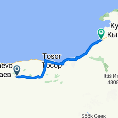
KAZ_KIR_13.jun_5.diena
A cycling route starting in Kadzhi-Say, Issyk-Kul Region, Kyrgyzstan.
Overview
About this route
- -:--
- Duration
- 139.8 km
- Distance
- 819 m
- Ascent
- 623 m
- Descent
- ---
- Avg. speed
- ---
- Max. altitude

Continue with Bikemap
Use, edit, or download this cycling route
You would like to ride KAZ_KIR_13.jun_5.diena or customize it for your own trip? Here is what you can do with this Bikemap route:
Free features
- Save this route as favorite or in collections
- Copy & plan your own version of this route
- Split it into stages to create a multi-day tour
- Sync your route with Garmin or Wahoo
Premium features
Free trial for 3 days, or one-time payment. More about Bikemap Premium.
- Navigate this route on iOS & Android
- Export a GPX / KML file of this route
- Create your custom printout (try it for free)
- Download this route for offline navigation
Discover more Premium features.
Get Bikemap PremiumFrom our community
Other popular routes starting in Kadzhi-Say
 Kadzhi-Say - Kyzyl-Suu
- Distance
- 73.3 km
- Ascent
- 18 m
- Descent
- 731 m
- Location
- Kadzhi-Say, Issyk-Kul Region, Kyrgyzstan
 Km 108-Balikchi
- Distance
- 116.7 km
- Ascent
- 623 m
- Descent
- 595 m
- Location
- Kadzhi-Say, Issyk-Kul Region, Kyrgyzstan
 Tosor Pass
- Distance
- 34.7 km
- Ascent
- 2,289 m
- Descent
- 8 m
- Location
- Kadzhi-Say, Issyk-Kul Region, Kyrgyzstan
 Kirgistan 80 Rowerów Dzień 10-
- Distance
- 52.6 km
- Ascent
- 162 m
- Descent
- 575 m
- Location
- Kadzhi-Say, Issyk-Kul Region, Kyrgyzstan
 Tosot-Naryn
- Distance
- 202.1 km
- Ascent
- 4,207 m
- Descent
- 3,763 m
- Location
- Kadzhi-Say, Issyk-Kul Region, Kyrgyzstan
 KAZ_KIR_13.jun_5.diena
- Distance
- 139.8 km
- Ascent
- 819 m
- Descent
- 623 m
- Location
- Kadzhi-Say, Issyk-Kul Region, Kyrgyzstan
Open it in the app