
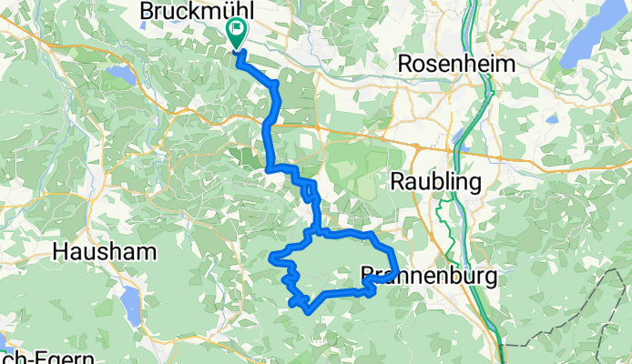
Tregleralm - Schuhbräualm - Schlipfgrubalm - Schwarzlack (Brannenburg)
A cycling route starting in Bruckmühl, Bavaria, Germany.
Overview
About this route
Steiles Tragestück zur Schuhbräualm
- -:--
- Duration
- 59.3 km
- Distance
- 1,166 m
- Ascent
- 1,165 m
- Descent
- ---
- Avg. speed
- ---
- Max. altitude
Continue with Bikemap
Use, edit, or download this cycling route
You would like to ride Tregleralm - Schuhbräualm - Schlipfgrubalm - Schwarzlack (Brannenburg) or customize it for your own trip? Here is what you can do with this Bikemap route:
Free features
- Save this route as favorite or in collections
- Copy & plan your own version of this route
- Sync your route with Garmin or Wahoo
Premium features
Free trial for 3 days, or one-time payment. More about Bikemap Premium.
- Navigate this route on iOS & Android
- Export a GPX / KML file of this route
- Create your custom printout (try it for free)
- Download this route for offline navigation
Discover more Premium features.
Get Bikemap PremiumFrom our community
Other popular routes starting in Bruckmühl
 Stachöd - Rosenheimer Straße 18
- Distance
- 24.5 km
- Ascent
- 263 m
- Descent
- 274 m
- Location
- Bruckmühl, Bavaria, Germany
 Moderate Route Irschenberg
- Distance
- 33.8 km
- Ascent
- 474 m
- Descent
- 474 m
- Location
- Bruckmühl, Bavaria, Germany
 Kleine Mangfall Runde
- Distance
- 10.7 km
- Ascent
- 25 m
- Descent
- 28 m
- Location
- Bruckmühl, Bavaria, Germany
 Bruckmühl Tunt Rott RDG Ottob 65 km 320hm
- Distance
- 64.2 km
- Ascent
- 207 m
- Descent
- 205 m
- Location
- Bruckmühl, Bavaria, Germany
 Maxhofen - Kleinhöhenrain
- Distance
- 11.4 km
- Ascent
- 199 m
- Descent
- 199 m
- Location
- Bruckmühl, Bavaria, Germany
 Von Baum zu Baum - Tour 1 - Nord
- Distance
- 39.8 km
- Ascent
- 369 m
- Descent
- 370 m
- Location
- Bruckmühl, Bavaria, Germany
 Mangfallschleife
- Distance
- 44 km
- Ascent
- 561 m
- Descent
- 561 m
- Location
- Bruckmühl, Bavaria, Germany
 Bruckmühl - Irschenberg - Janoschrunde
- Distance
- 29.8 km
- Ascent
- 320 m
- Descent
- 320 m
- Location
- Bruckmühl, Bavaria, Germany
Open it in the app