

Torroella de Montgrí-Verges-Bellcaire-Torroella
A cycling route starting in Torroella de Montgrí, Catalonia, Spain.
Overview
About this route
Connected between road and gravel. Well marked and easy to follow. Up to Verges very flat with a first part close to the river very pleasant. Slope towards Tallada d'E. and Maranyà. Up to Tor, climbs and descents. At Tor, be careful on a hundred-meter stretch of the C31 road. Up to Bellcaire very pleasant, you can take a path and not enter it. Up to Ullà is a road preferred by cyclists. The last stretch between Ullà and Torroella is not the most beautiful.
- -:--
- Duration
- 24.6 km
- Distance
- 102 m
- Ascent
- 102 m
- Descent
- ---
- Avg. speed
- ---
- Max. altitude

Route highlights
Points of interest along the route
Point of interest after 15.2 km
Encreuament perillós, feu atenció.
Continue with Bikemap
Use, edit, or download this cycling route
You would like to ride Torroella de Montgrí-Verges-Bellcaire-Torroella or customize it for your own trip? Here is what you can do with this Bikemap route:
Free features
- Save this route as favorite or in collections
- Copy & plan your own version of this route
- Sync your route with Garmin or Wahoo
Premium features
Free trial for 3 days, or one-time payment. More about Bikemap Premium.
- Navigate this route on iOS & Android
- Export a GPX / KML file of this route
- Create your custom printout (try it for free)
- Download this route for offline navigation
Discover more Premium features.
Get Bikemap PremiumFrom our community
Other popular routes starting in Torroella de Montgrí
 rando round
- Distance
- 1.8 km
- Ascent
- 39 m
- Descent
- 36 m
- Location
- Torroella de Montgrí, Catalonia, Spain
 emporda 50km
- Distance
- 52.7 km
- Ascent
- 248 m
- Descent
- 239 m
- Location
- Torroella de Montgrí, Catalonia, Spain
 Torroella de Montgrí-Verges-Bellcaire-Torroella
- Distance
- 24.6 km
- Ascent
- 90 m
- Descent
- 90 m
- Location
- Torroella de Montgrí, Catalonia, Spain
 VADEBICI. Diumenge 15-03-2015, "RUTA MÀGICA POBLETS DE L'EMPORDÀ 3"
- Distance
- 41.8 km
- Ascent
- 221 m
- Descent
- 199 m
- Location
- Torroella de Montgrí, Catalonia, Spain
 Escala_port_Villa
- Distance
- 21.4 km
- Ascent
- 241 m
- Descent
- 241 m
- Location
- Torroella de Montgrí, Catalonia, Spain
 Relaxed route in
- Distance
- 24.6 km
- Ascent
- 388 m
- Descent
- 418 m
- Location
- Torroella de Montgrí, Catalonia, Spain
 Estartit, dunes, Puig segalar, Dunes, Rocamoura Estartit
- Distance
- 50.4 km
- Ascent
- 503 m
- Descent
- 503 m
- Location
- Torroella de Montgrí, Catalonia, Spain
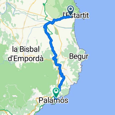 23.10.25: Torroella de Montgrí-Palamós
- Distance
- 34.8 km
- Ascent
- 230 m
- Descent
- 205 m
- Location
- Torroella de Montgrí, Catalonia, Spain
Open it in the app