

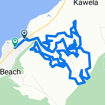
Pupukea
A cycling route starting in Pupukea, Hawaii, United States.
Overview
About this route
- -:--
- Duration
- 24.3 km
- Distance
- 724 m
- Ascent
- 706 m
- Descent
- ---
- Avg. speed
- ---
- Max. altitude
Continue with Bikemap
Use, edit, or download this cycling route
You would like to ride Pupukea or customize it for your own trip? Here is what you can do with this Bikemap route:
Free features
- Save this route as favorite or in collections
- Copy & plan your own version of this route
- Sync your route with Garmin or Wahoo
Premium features
Free trial for 3 days, or one-time payment. More about Bikemap Premium.
- Navigate this route on iOS & Android
- Export a GPX / KML file of this route
- Create your custom printout (try it for free)
- Download this route for offline navigation
Discover more Premium features.
Get Bikemap PremiumFrom our community
Other popular routes starting in Pupukea
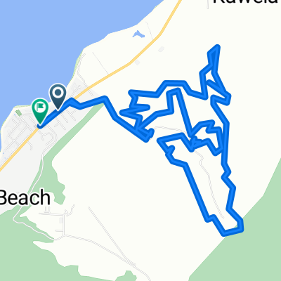
 Wehiwa Way, Pūpūkea to Wehiwa Way, Pūpūkea
- Distance
- 19.6 km
- Ascent
- 648 m
- Descent
- 652 m
- Location
- Pupukea, Hawaii, United States
 Mamao St, Pūpūkea to Wehiwa Way, Pūpūkea
- Distance
- 20.8 km
- Ascent
- 711 m
- Descent
- 708 m
- Location
- Pupukea, Hawaii, United States
 Pupukea
- Distance
- 24.3 km
- Ascent
- 724 m
- Descent
- 706 m
- Location
- Pupukea, Hawaii, United States
 Oahu 5
- Distance
- 55.3 km
- Ascent
- 156 m
- Descent
- 156 m
- Location
- Pupukea, Hawaii, United States
 Kamehameha Hwy, Pūpūkea to Wehiwa Way, Pūpūkea
- Distance
- 15.6 km
- Ascent
- 560 m
- Descent
- 557 m
- Location
- Pupukea, Hawaii, United States
 Moderate route in Pūpūkea
- Distance
- 5.6 km
- Ascent
- 204 m
- Descent
- 201 m
- Location
- Pupukea, Hawaii, United States
 59-754 Kamehameha Hwy, Pūpūkea to 59-337 Ke Nui Rd, Pūpūkea
- Distance
- 2.6 km
- Ascent
- 72 m
- Descent
- 78 m
- Location
- Pupukea, Hawaii, United States
 Wehiwa Pl, Pūpūkea to Wehiwa Way, Pūpūkea
- Distance
- 20.4 km
- Ascent
- 678 m
- Descent
- 679 m
- Location
- Pupukea, Hawaii, United States
Open it in the app