

Salta
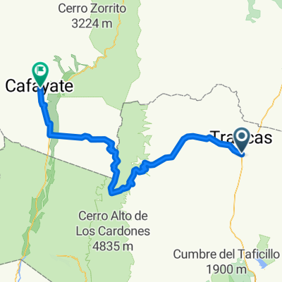
Trancas - El Jardín - Pampa Grande - Cafayate
A cycling route starting in Trancas, Tucumán Province, Argentina.
Overview
About this route
From Trancas, along the old RN9.
El Jardin, Pampa Grande.
Then along the service road of high tension towers.
RN68 and Cafayate.
- -:--
- Duration
- 173.5 km
- Distance
- 2,531 m
- Ascent
- 1,685 m
- Descent
- ---
- Avg. speed
- ---
- Max. altitude

Part of
Salta
1 stage
Route highlights
Points of interest along the route
Accommodation after 89.4 km
Estancia Pampa Grande
Continue with Bikemap
Use, edit, or download this cycling route
You would like to ride Trancas - El Jardín - Pampa Grande - Cafayate or customize it for your own trip? Here is what you can do with this Bikemap route:
Free features
- Save this route as favorite or in collections
- Copy & plan your own version of this route
- Split it into stages to create a multi-day tour
- Sync your route with Garmin or Wahoo
Premium features
Free trial for 3 days, or one-time payment. More about Bikemap Premium.
- Navigate this route on iOS & Android
- Export a GPX / KML file of this route
- Create your custom printout (try it for free)
- Download this route for offline navigation
Discover more Premium features.
Get Bikemap PremiumFrom our community
Other popular routes starting in Trancas
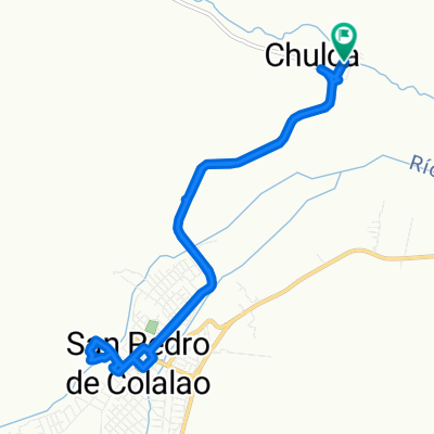 chulca-sp
- Distance
- 15.3 km
- Ascent
- 256 m
- Descent
- 260 m
- Location
- Trancas, Tucumán Province, Argentina
 De Unnamed Road a Unnamed Road
- Distance
- 30.5 km
- Ascent
- 158 m
- Descent
- 157 m
- Location
- Trancas, Tucumán Province, Argentina
 desde el tala a la viña
- Distance
- 133.4 km
- Ascent
- 1,493 m
- Descent
- 1,129 m
- Location
- Trancas, Tucumán Province, Argentina
 Trancas - San Pedro de Colalao
- Distance
- 23.1 km
- Ascent
- 323 m
- Descent
- 29 m
- Location
- Trancas, Tucumán Province, Argentina
 San Pedro de Colalao - Cafayate
- Distance
- 149 km
- Ascent
- 3,139 m
- Descent
- 2,277 m
- Location
- Trancas, Tucumán Province, Argentina
 De Belgrano, Trancas a Antonio Díaz, Choromoro
- Distance
- 25.4 km
- Ascent
- 34 m
- Descent
- 32 m
- Location
- Trancas, Tucumán Province, Argentina
 Easy ride in La Candelaria
- Distance
- 27.7 km
- Ascent
- 490 m
- Descent
- 478 m
- Location
- Trancas, Tucumán Province, Argentina
 Trancas - El Jardín - Pampa Grande - Cafayate
- Distance
- 173.5 km
- Ascent
- 2,531 m
- Descent
- 1,685 m
- Location
- Trancas, Tucumán Province, Argentina
Open it in the app