

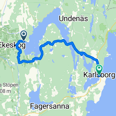
12Tatorp-Karlsborg
A cycling route starting in Töreboda, Västra Götaland County, Sweden.
Overview
About this route
Tatorp über Forsvik nach Karlsborg
Karlsborgs Camping Norra vägen 3, 546 33 Karlsborg
Telefon: 0505-120 22 Fax: 0505-120 22
Platznummer: R12 Umgebung: Västergötland
Karlsborgs Camping liegt 5 Minuten vom Stadtzentrum entfernt. Sehr hübsch am Näset zwischen Vättern und Bottensjö gelegen. Bei uns können Sie wählen, in Ihrem eigenen Wohnwagen oder Zelt übernachten, und wenn Sie keine eigene Unterkunft mit dir, warum nicht ein Haus mieten oder einen ”Baumstumpf”! Sie können an unserem kinderfreundlichen Strand schwimmen und sonnenbaden. Hier gibt es sowohl einen seichten Sandstrand, als auch einen Steg - perfekt also für Familien mit Kindern. Auch Kanus und Tretboote kann man sich ausleihen. Warum nicht eine Tour über den See Bottensjön machen? Außerhalb des Geländes in Richtung Göta Kanal kann man Beachvolleyball spielen und an der Rezeption haben wir einen neuen Minigolfplatz angelegt. Sollten Sie Lust bekommen, Fahrrad zu fahren, zu joggen oder einen Spaziergang zu machen, dann bieten die hübschen Wege in der Umgebung ausgezeichnete Möglichkeiten. Boote, Kanus und Fahrräder kann man sich an der Rezeption ausleihen. In unserem Servicegebäude finden Sie eine gemeinsame Küche mit Herd, Ofen und Mikrowelle, TV-Zimmer, Dusche, WC und Waschraum. Für Warmwasser in den Duschen braucht man 5 SEK-Stücke. Auschecken für Campinggäste spätestens um 15:00 Uhr und Ferienhausgäste spätestens um 12:00 Uhr. Autoverkehr ist auf dem Gelände zwischen 23:00 Uhr – 06:00 Uhr untersagt.
- -:--
- Duration
- 38.3 km
- Distance
- 205 m
- Ascent
- 211 m
- Descent
- ---
- Avg. speed
- ---
- Max. altitude
Route quality
Waytypes & surfaces along the route
Waytypes
Road
19.6 km
(51 %)
Quiet road
6.7 km
(18 %)
Surfaces
Paved
31.1 km
(81 %)
Unpaved
4.8 km
(12 %)
Paved (undefined)
19.2 km
(50 %)
Asphalt
11.9 km
(31 %)
Continue with Bikemap
Use, edit, or download this cycling route
You would like to ride 12Tatorp-Karlsborg or customize it for your own trip? Here is what you can do with this Bikemap route:
Free features
- Save this route as favorite or in collections
- Copy & plan your own version of this route
- Sync your route with Garmin or Wahoo
Premium features
Free trial for 3 days, or one-time payment. More about Bikemap Premium.
- Navigate this route on iOS & Android
- Export a GPX / KML file of this route
- Create your custom printout (try it for free)
- Download this route for offline navigation
Discover more Premium features.
Get Bikemap PremiumFrom our community
Other popular routes starting in Töreboda
 Vassbacken 14, Töreboda to Järnvägsgatan 8, Laxå
- Distance
- 67.1 km
- Ascent
- 438 m
- Descent
- 428 m
- Location
- Töreboda, Västra Götaland County, Sweden
 Tag 08
- Distance
- 72.9 km
- Ascent
- 357 m
- Descent
- 348 m
- Location
- Töreboda, Västra Götaland County, Sweden
 Jonsboda
- Distance
- 80.5 km
- Ascent
- 287 m
- Descent
- 287 m
- Location
- Töreboda, Västra Götaland County, Sweden
 Sweden day 6 - nora
- Distance
- 137.2 km
- Ascent
- 1,165 m
- Descent
- 1,193 m
- Location
- Töreboda, Västra Götaland County, Sweden
 Kungsgatan 10 to Lugnås församling
- Distance
- 52.5 km
- Ascent
- 114 m
- Descent
- 94 m
- Location
- Töreboda, Västra Götaland County, Sweden
 12Tatorp-Karlsborg
- Distance
- 38.3 km
- Ascent
- 205 m
- Descent
- 211 m
- Location
- Töreboda, Västra Götaland County, Sweden
 Götakanal + Vikenseeumrundung
- Distance
- 79.4 km
- Ascent
- 350 m
- Descent
- 343 m
- Location
- Töreboda, Västra Götaland County, Sweden
 Vallevägen-Hornborgasjön Dag 1
- Distance
- 63.9 km
- Ascent
- 185 m
- Descent
- 136 m
- Location
- Töreboda, Västra Götaland County, Sweden
Open it in the app