
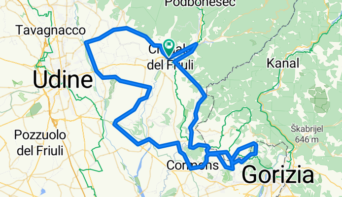
Cividale 01 -- 104km 660hm
A cycling route starting in Cividale del Friuli, Friuli Venezia Giulia, Italy.
Overview
About this route
Starter tour with options to shorten (possibly in bad weather) of a maximum of 30km.
At km51, turn right to a winery (those who do not want to go just continue straight on the road).
At km53 (by the school) go right (straight ahead) continuing. DO NOT TURN LEFT!
After km54 before the curve turn left (going straight) (uphill).
Anyone who does NOT want to ride the 100 can continue straight after km93 (still before the hospital) and go through the roundabout into VIA EUROPA. At the end of the street at the traffic light turn right (Borgo di Ponte) and cross the bridge home.
- -:--
- Duration
- 104 km
- Distance
- 411 m
- Ascent
- 408 m
- Descent
- ---
- Avg. speed
- ---
- Max. altitude

Route quality
Waytypes & surfaces along the route
Waytypes
Road
47.8 km
(46 %)
Quiet road
17.7 km
(17 %)
Surfaces
Paved
70.7 km
(68 %)
Unpaved
3.1 km
(3 %)
Asphalt
70.7 km
(68 %)
Gravel
2.1 km
(2 %)
Continue with Bikemap
Use, edit, or download this cycling route
You would like to ride Cividale 01 -- 104km 660hm or customize it for your own trip? Here is what you can do with this Bikemap route:
Free features
- Save this route as favorite or in collections
- Copy & plan your own version of this route
- Split it into stages to create a multi-day tour
- Sync your route with Garmin or Wahoo
Premium features
Free trial for 3 days, or one-time payment. More about Bikemap Premium.
- Navigate this route on iOS & Android
- Export a GPX / KML file of this route
- Create your custom printout (try it for free)
- Download this route for offline navigation
Discover more Premium features.
Get Bikemap PremiumFrom our community
Other popular routes starting in Cividale del Friuli
 Cividale del Friuli - nördl. Hügelrunde
- Distance
- 87.4 km
- Ascent
- 2,518 m
- Descent
- 2,521 m
- Location
- Cividale del Friuli, Friuli Venezia Giulia, Italy
 Cividale 01 -- 104km 660hm
- Distance
- 104 km
- Ascent
- 411 m
- Descent
- 408 m
- Location
- Cividale del Friuli, Friuli Venezia Giulia, Italy
 CIVIDALE-MONTE JONAZ
- Distance
- 45.3 km
- Ascent
- 1,088 m
- Descent
- 1,088 m
- Location
- Cividale del Friuli, Friuli Venezia Giulia, Italy
 A cerca di gua(d)i tra Grivò e Chiarò
- Distance
- 29.4 km
- Ascent
- 48 m
- Descent
- 48 m
- Location
- Cividale del Friuli, Friuli Venezia Giulia, Italy
 corsa per haiti 2017
- Distance
- 141.8 km
- Ascent
- 2,530 m
- Descent
- 2,528 m
- Location
- Cividale del Friuli, Friuli Venezia Giulia, Italy
 Matajur a Passo S.Martino
- Distance
- 70.4 km
- Ascent
- 1,442 m
- Descent
- 1,441 m
- Location
- Cividale del Friuli, Friuli Venezia Giulia, Italy
 A sud di Cividale
- Distance
- 56.6 km
- Ascent
- 410 m
- Descent
- 411 m
- Location
- Cividale del Friuli, Friuli Venezia Giulia, Italy
 cividale-clenia-cepletischis-masseris-m.te matajur
- Distance
- 29.5 km
- Ascent
- 1,282 m
- Descent
- 104 m
- Location
- Cividale del Friuli, Friuli Venezia Giulia, Italy
Open it in the app